
Black Warrior River is High! Weekend Weather Pictures – Monday Update 4:45pm
Updated: 2012-01-30 22:51:23
These pictures were sent to us by Gary Tate over the weekend. This is the Black Warrior near Lock 8 in the Akron area. With all the rain lately, many creeks and rivers have been swollen over the past couple of weeks. There are still river flood warnings in place for the Black Warrior [...]
 Good Monday afternoon to you! I had a great time speaking to the Senior Citizen Group at Stillman College today! I’ll show video of the visit on WVUA-TV news at 5, 6, and 10pm. After a cold start to the day, it’s warmed up nicely this afternoon. Many spots started off in the 20s; in-fact, [...]
 : Cliff Mass Weather Blog This blog provides updated forecasts and comments on current weather or other topics Monday , January 30, 2012 Destruction Hits Two Sacred Weather Locations I was worried last week that when I revealed the secrets of the Devil's Weather Triangle near Napavine that some of the weather deities would be displeased . nbsp Such are the risks I take for this blog Unfortunately , my fears were realized and two of the most sacred weather sites of the Northwest have been struck and damaged by sudden and unexpected severe weather . nbsp Not strong enough to destroy them , but enough to deliver a message . nbsp This can not be consider a . coincidence My Napavine Triangle blog went out late Tuesday , and by Thursday morning a terrible fate struck my favorite weather-themed
 More dry conditions for the next couple of days with temperatures getting warmer each day. There is high pressure over the Southeast which has brought these dry conditions. It has also allowed our overnight temperatures to drop below freezing the past couple of nights. That will all begin to change Monday evening when the ridge [...]
 Did those of you around Whidbey Island hear a big clap of thunder around 1:30 a.m. Sunday morning? This brilliant lightning strike, captured on tape, was likely the culprit.
 Much drier air is filtering into the area behind a cold front that moved across the state this afternoon. Overnight lows will drop into the low 20s to low 30s. Sunday, high pressure builds back into the area with highs into the 50s to around 60. After one more cool night Sunday, temperatures will start [...]
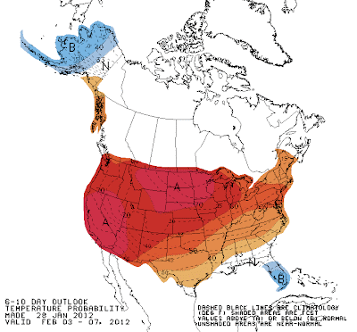 : Cliff Mass Weather Blog This blog provides updated forecasts and comments on current weather or other topics Saturday , January 28, 2012 An Unusual Winter Around the Country The weather is rarely normal and most years there are some large excursions from average conditions , but this year is rapidly becoming memorable over the eastern two-thirds of the country and . Alaska In much of eastern U.S . winter hasn't really taken hold , with record maximum temperatures occurring on many days , and monthly averages being way above normal . nbsp Here are the anomalies difference from normal of the daily-average temperatures across the U.S . for the past 90 and 30 days see below For the last 90 days nearly all locations over and west of the Rockies has been much warmer than normal . with some
 Here’s a nice image from our Tuscaloosa Towercam, looking west over Bryant-Denny Stadium. Send us your weather pictures! Send them to weather@wvuatv.com. Also, look us up on facebook and twitter by searching weather@wvuatv.com or searching WVUA-TV Weather. We also have a new like page on facebook, called WVUA-TV Weather. Since we’re running out of [...]
 …ISOLATED TORNADO DAMAGE AND MINOR FLOODING FROM THURSDAY’S STORMS… …UPDATED FOR UNIONTOWN TORNADO DETAILS. STORM SURVEYS COMPLETED… A LINE OF SHOWERS AND THUNDERSTORMS MOVED THROUGH CENTRAL ALABAMA THURSDAY MORNING AND AFTERNOON IN ADVANCE OF AN APPROACHING COLD FRONT. THE THREAT FOR SEVERE WEATHER WAS LIMITED AS THE WARM MOIST AND UNSTABLE AIR EXPECTED TO MOVE [...]
 A good Friday afternoon to you! It’s been a very nice day across our state, with a sunny sky and cool temperatures. Many spots are back in the upper 50s to lower 60s this afternoon, which is a little above average. The storm system that brought heavy rain to much of the state is [...]
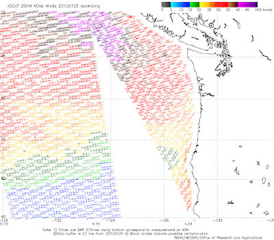 : Cliff Mass Weather Blog This blog provides updated forecasts and comments on current weather or other topics Thursday , January 26, 2012 The Truth About the Pacific Data Void How often do you hear statements like this Forecasting skill is bad on the West Coast because there are few weather observations over the . Pacific We don't know what is coming from the west , so it is impossible to forecast in the . Northwest In reality these statements are really not . true We have a huge amount of information over the Pacific and that is probably the main reason why weather forecasts have improved so much over the past 30 . years So what observing assets do we have out there Be ready to be impressed We start with weather buoys , as shown by this map red diamonds indicate stations that have not
 A good Thursday evening to you! The final batch of shower and thunderstorms are working through parts of the area this evening, as a cold front moves in from the northwest. The storms are below severe limits and should stay that way through the rest of the evening. If you get any additional rain [...]
 Here’s the latest national weather service findings on Monday morning’s tornado outbreak. There have now been 11 tornadoes found within central Alabama’s damage. TORNADO #1…KOFFMAN TORNADO (TUSCALOOSA)… EVENT DATE: JANUARY 23, 2012 EVENT TYPE: EF-3 ESTIMATED PEAK WINDS (MPH): 140 INJURIES/FATALITIES: 0 EVENT START TIME/LOCATION COORDINATES: 33.3257/-87.6579 AT 242 AM EVENT END TIME/LOCATION COORDINATES: 33.3305/-87.6526 [...]
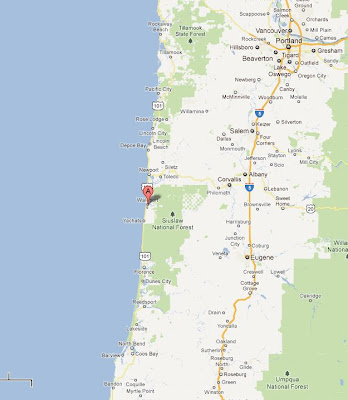 : Cliff Mass Weather Blog This blog provides updated forecasts and comments on current weather or other topics Tuesday , January 24, 2012 The Bermuda Triangle of Northwest Weather Some things are beyond scientific understanding . nbsp Weather phenomena that can not be explained by forecast models and high-tech observations . Occurrences that are known by local meteorologists but are rarely spoken about in public . nbsp Perhaps the best-known example : nbsp the Napavine Triangle Napavine is located in southwest Washington , between Olympia and Portland--a few miles south of Chehalis see graphic A closer look at the terrain reveals a triangular valley second map A valley with extreme and often bizarre . weather Doubtful You won't be in a few minutes . nbsp During the snows last week , which
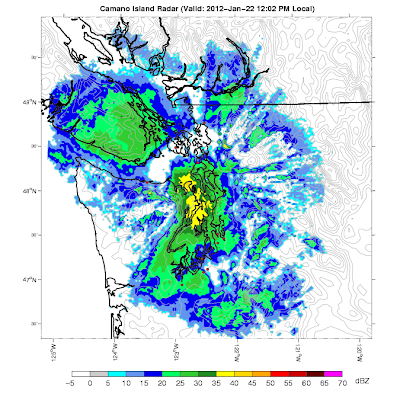 : Cliff Mass Weather Blog This blog provides updated forecasts and comments on current weather or other topics Sunday , January 22, 2012 Southeast Olympic Snowstorm and Teasing the Seattle Times It is snowing right now at fairly low elevations to the southeast of the Olympics--something that happens a few times every winter . nbsp For example , here is an image from Dale Ireland's home above Hood Canal At the same time it is raining and in the upper 30s and lower 40s in much of the rest of the area . nbsp How can this be The National Weather Service has been spotlighting this possibility for a while and the local high resolution models were going for this snow for days see forecast from yesterday below-24h snowfall ending 4 PM for forecast initialized 4 PM . yesterday The key to this is
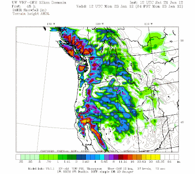 : Cliff Mass Weather Blog This blog provides updated forecasts and comments on current weather or other topics Saturday , January 21, 2012 The Other Snow Story During the past several days , this blog was been fixated on lowland snow and ice . nbsp Later I would like to talk more about the ice storm , which has been one of the major meteorological disasters of the past decade , with roughly 300,000 customer losing power , massive loss of trees , extensive road closures , and loss of . life But another important weather story has been the huge increase in snowpack during the past week over the Cascades . nbsp Below is the NOAA snowdepth graphics comparing January 13th to today . nbsp Big increases . nbsp Enough to make ski operators and outdoor enthusiasts . smile Before After A week ago ,
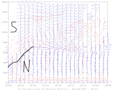 : Cliff Mass Weather Blog This blog provides updated forecasts and comments on current weather or other topics Thursday , January 19, 2012 The End is Near This snow sleet freezing rain evident is basically done . nbsp And we are not talking about forecasts . observations show its . demise First , only a handful of observing sites in the south Sound are indicating a few light snow or freezing drizzle showers . this will end soon The radar shows NOTHING : offshore But most important of all , the profiler at Sand Point in Seattle shows southerly winds and warmer temperatures rapidly descending towards the surface , at this rate we should see the end of the cool northerly flow over the Sound and a replacement by warming southerlies by daybreak latest observations on the left side I have
 This is a long forecast given i will be in New Orleans from Saturday through Wednesday for the AMS conference. This means I will not be able to update any severe warnings Sunday Night/Monday. I may ask someone else to cover … Continue reading →
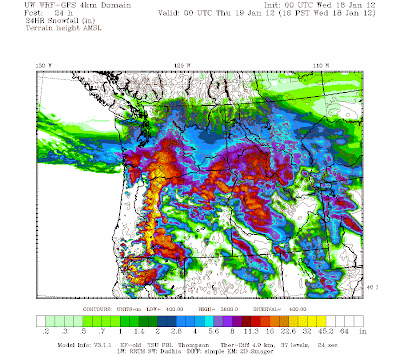 : Cliff Mass Weather Blog This blog provides updated forecasts and comments on current weather or other topics Tuesday , January 17, 2012 A Snowstorm of Two Characters The latest forecast models runs suggest a snow event of two characters . nbsp Over the mountains and over southwest Washington there will be large quantities of snow . nbsp And substantial snow over the eastern slopes of the Cascades . nbsp But over Puget Sound and northwest Washington this will be a very modest affair . nbsp In fact , many of you over the north Sound and Whidbey Island got WAY more snow today than you will get . tomorrow Right now two signs of the incipient action are evident . nbsp First , the Langley Hill coastal radar is now showing the leading precipitation clouds . nbsp You really have to love this
 By J.Braun An impressive overrunning snow event is on tap for much of western Washington Tuesday, January 17th with bands of snow showers moving inland across northwestern Washington. The (mainly) snow shower activity has increased in coverage as mid level … Continue reading →
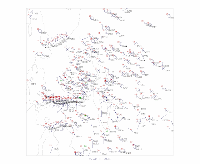 : Cliff Mass Weather Blog This blog provides updated forecasts and comments on current weather or other topics Sunday , January 15, 2012 Interesting Differences in Local Snow Today there were dramatic differences of snow--even within the City of Seattle--that illustrate some of the challenges of forecasting around . here Some of you in Ballard and northwest Seattle complained that you hardly saw much snow while luck denizens of Capitol Hill , perhaps 5-6 miles away , got 3-4 inches in places . nbsp Here are a few pictures from Capitol Hill , courtesy of Joseph Chan , a UW undergrad taken around 2:20 PM You notice the Seattle DOT plow on the job A lot of . snow It turns out there was a band of heavy precipitation--oriented southwest to northeast- that remained quasi-stationary and crossed
 Podcasting Gear Mixer -Behringer Xenyx 1202FX 12 channel/4-XLR built in 24 bit FX processor Microphone – Behringer Wind screen/pop filter – cheaper than getting a good pop filter cables – standard 15ft. XLR mic stand – gotta boom stand. iPod – my Nano Audacity – This is what I record in iTunes – Various music [...]
 : Cliff Mass Weather Blog This blog provides updated forecasts and comments on current weather or other topics Thursday , January 12, 2012 The Upcoming Snow I waited to write this blog until I could see the whites of their eyes and this case white is the right . color It really looks like there will be some lowland snow late Saturday into Sunday . but not the heavy , widespread variety . nbsp It is clear that the mountains will get quite a bit during the next week and that the entire region will go through a much colder period starting later on . Saturday As I have mentioned on a number of occasions , it is easy for the western lowlands to be mild and wet , since most weather systems come from the west , passing over the relatively warm Pacific sea surface temps around 50F Sometimes we are
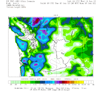 : Cliff Mass Weather Blog This blog provides updated forecasts and comments on current weather or other topics Tuesday , January 10, 2012 Increasing Threat of Snow The new forecast models are increasingly threatening for colder temperatures and lowland snow from Sunday through Wednesday of next week , although none of the forecast are ideal for a truly major event . nbsp THUS THIS EVENT SHOULD NOT BE OVERHYPED At this point we are talking about good snowfalls in the mountains and snow showers over the . lowlands But you might consider getting prepared : nbsp make sure you have chains and windshield decider for your car , be ready to protect sensitive plants-- you know what I mean . nbsp The TV stations should get all their colorful parkas cleaned and ready no KING-5 Jim Forman jokes . yet
 I’m at home now, getting ready for bed, but I wanted to let everyone know that we may be in for a decent storm if everything comes together. The winds won’t be as bad as the previous storm, but if the storm track bears out we could get a lot of snow. The graphic to [...]
 : Cliff Mass Weather Blog This blog provides updated forecasts and comments on current weather or other topics Monday , January 9, 2012 Winter Over Don't Bet on It Bicycling in today , I marveled how spring-like it was . nbsp Mild temperatures well above normal . nbsp The grass is really growing--starting much earlier than normal . nbsp At the UW , I could see large number of bulbs pushing up in the beds . nbsp And it has been warmer than normal for weeks now--take a look at the comparison between Sea-Tacs temps and : normal The normal high is around 45F and we have been hitting 50F and beyond on a regular basis . nbsp Very good for my lost . dog The National Weather Service extended forecasts have repeatedly called for a return to normal La Nina conditions--wetter than normal and colder
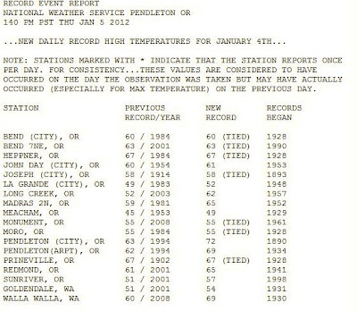 : Cliff Mass Weather Blog This blog provides updated forecasts and comments on current weather or other topics Thursday , January 5, 2012 The Other Heat Wave TV Notice : nbsp KBTC TV One of our local public tv stations will be doing a special on the Langley Hill radar on Monday , Jan 9th at 6:30 PM . nbsp More information here : http : www.kbtc.org pop_schedule.php id=22977 Yesterday , there as also another local heat wave . one related to the Eatonville heat burst : nbsp several locations in eastern Oregon and Washington got into the upper 60s , with downtown Walla Walla hitting 72F . nbsp Here is the official record report from the : NWS Warm air aloft , strong southerly winds , and terrain are the cause--just as the case for Eatonville . nbsp The north side of the Oregon Blue Mountains