Let’s rock out!
Updated: 2011-09-30 20:33:40
VID_20110820_130003.3gp Watch on Posterous I like his taste in music.

 No sooner did September start that our first cold air outbreak occur and we are getting lake effect rain showers. Droplets were a little hard to see in the picture, but the somewhat lowered visibility can be seen with the break in the clouds. Here’s the radar from the afternoon with the rain band [...]
 This morning we ventured south. We stopped in Otis at the Otis café to have breakfast. We stopped next in Depoe Bay and saw three California Gray Whales. Next to Yaquina Head Lighthouse, more whales and a perrigrine falcon. Then we stopped at Newport to see the sea lions. Now lunch! See the full gallery [...]
 Travelled to the Pacific coast, specifically Pacific City, OR. We are in a rental for a few nights. Took Mary over the dune to see the ocean. High waves and the tide is coming in.The water is cold, like 50 degrees. Wow that was cold on the feet. See the full gallery on Posterous
 Today, we all travelled to Astoria. It started out with coffee near we are staying, then to Camp 18 restaurant for breakfast. We stopped at a few spots along the way. The highlight was climbing the tower at Astoria and seeing the mouth of the Columbia. I'll try and get all of our pictures together, [...]
 For all of the years I have lived in and around Gaylord, I've never attended the Fair. Now, because of a longer story I won't tell here, Mary and her friend Liz, have inherited the Avon booth at the fair. Tonight, we are setting it up.
 Today, Dad and I spent some time at the Evergreen Aviation Museum. Mary and Mom are out shopping, or something. Here are a few pictures of my favorite planes. See the full gallery on Posterous
 Originally Published: ec. 15, 2008:
A beer tornado? Take a gander at what KOMO photographer Doug Pigsley captured on video in Downtown Seattle Friday afternoon as the gusty winds swirled around downtown Seattle.
Originally Published: ec. 15, 2008:
A beer tornado? Take a gander at what KOMO photographer Doug Pigsley captured on video in Downtown Seattle Friday afternoon as the gusty winds swirled around downtown Seattle. A good Thursday afternoon to you! It’s fairly warm this afternoon, with many folks returning into the middle 80s. This will be the last very warm day over the next 5 days, as cooler air takes over. A cold front is diving southeast right now, and should arrive tonight or early tomorrow. The front is [...]
 A good Wednesday afternoon to you! The cold front has finally cleared our area, with an increase in sunshine this afternoon. Big storms moved across our southern counties lastnight and very early this morning, but the complex of storms is moving off the coast at this hour. Many of us recovered into the lower 80s [...]
 Storms are increasing in east Mississippi and are expected to continue to increase tonight. Much like lastnight and this morning, a complex of storms are expected to develop. This may be happening now. The storms will increase in coverage and push east at 20 to 30 MPH. These storms will produce lots of lightning, but [...]
 The heavy rain is out of here now, but some spots picked up over 1 inch of rain. I’ll admit, the storms were further north than expected today. I had the best chance of storms south of Tuscaloosa, but much of west and central Alabama got in on this one. The old cold front is nearly [...]
 I just thought this was an interesting shot from our WVUA towercamera in Tuscaloosa. I think these house wrens were enjoying the mild weather this afternoon. WVUA Chief Meteorologist Richard Scott rscott@wvuatv.com
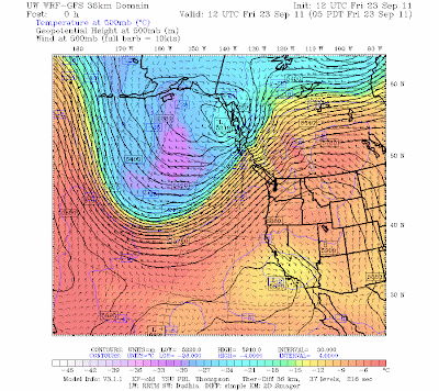 : Cliff Mass Weather Blog This blog provides updated forecasts and comments on current weather or other topics Friday , September 23, 2011 Sweating in the Pacific Northwest Bicycling to work today , I found myself wiping the sweat from my brow as I entered my building . nbsp It really felt like the East Coast during summer out there . In fact , the last few days we have had some unusually humid air over the region , with nighttime minimum temperatures far higher than we are accustomed to . nbsp The dewpoints were quite high this morning . rising into the mid-60s in some locations . nbsp In fact , during the past day we have had the most humid air of the summer invading our region . nbsp What is going on During the past several days we have had a pattern with unusually high pressure to our
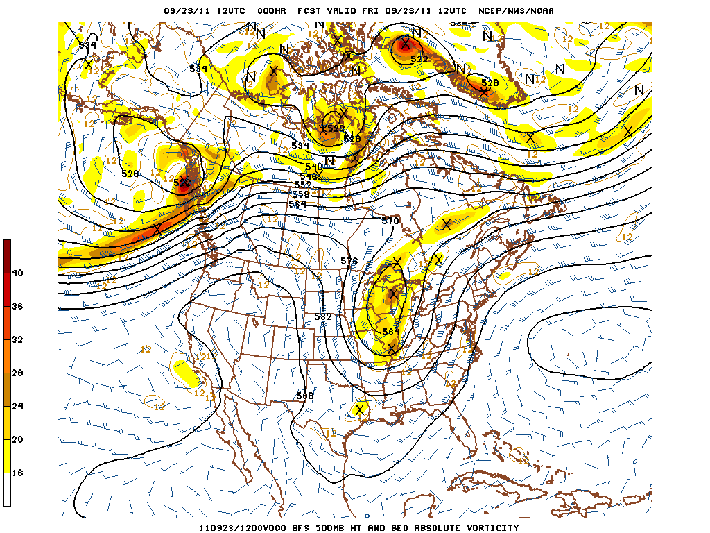 Highlights -First day of Fall starts out cool and wet -Cut-off 500 hPa low retrogrades westward -Wet weekend in store A potent upper level low is digging and progressing east-southeast at the moment over the midwest. We have seen a … Continue reading →
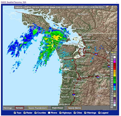 : . Cliff Mass Weather Blog This blog provides updated forecasts and comments on current weather or other topics Wednesday , September 21, 2011 The Big Day Arrives . The Washington Coastal Radar is Operational Today I received a wonderful email from Brad Colman , head of the Seattle National Weather Service Forecast Office : nbsp the new coastal radar , located just north of Hoquiam , is now fully operational and the data is flowing to the outside . world This radar , on top of Langley Hill , has been updated to include dual-polarization , which will allow a whole new collection of valuable . products Enough talk , here are some examples . nbsp Today there is a band of precipitation offshore that is slamming into Vancouver Island . nbsp Want to see Check below . nbsp Pretty impressive .
 Brian Barnes recently entered a photograph of a supercell that occurred in Nebraska on June 16, 2011 into Week 14 of National Geographic's "Travelers Photo Contest." The photo was one of 20 picked as an "Editor's Favorite" for Week 14.
 24 previously unseen photographs of the tsunami that struck Japan's northern coast on March 11, 2011. The following images are in no particular order of the events.
 As most know by now, I do a lot of volunteer work in the ocean activism community when I'm not storm chasing in Tornado Alley. I was in Otsuchi Japan (Iwate Prefecture) on March 11th, 2011 monitoring the slaughter of Dall's porpoises for Ric O'Barry's Save Japan Dolphins and standing just a few feet from the water on a man made pier in the middle of Otsuchi harbor when the M9.0 earthquake hit.
 We received several request for this print to be made into a poster - so here it is. No text - just a large 20 x 30 in print of this incredible tornado event!
 Brand new item in our StormChase.com Zazzle store - Campo Tornado and double rainbow on a mousepad. It looks great on your desk! They're great for starting conversations as well.
 I've decided to add a few new photos to the image gallery. Just as a shameless plug - I do sell the photos with a variety of frames and printing options, if you see something you'd like to hang on you wall - contact me!
 I've got to hand it to the Brits -- I would have never thought that weather could be fashionable and fun at the same time, but they've managed to accomplish both.
 You might have heard Hurricane Irene was pretty big from a geographical standpoint, but while it might be hard to fathom just how big a storm 700 mile across really is, perhaps NASA an help.
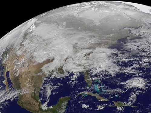 After all, they did leak the iPhone4 months before it was officially announced by Steve Jobs. Maybe they know something about this storm meteorologists dont know. Today they are talking about the big weather event that is affecting much of the central US today and will affect the northeast US tomorrow. As of this morning [...]
 Hey Everyone! Just a quick update. Things are well down in Asheville North Carolina! But we can’t wait to return to New England for the holiday season! I just wanted to point out the obvious… Technology is awesome! How awesome? This entire post was made on my iPod touch! While this concept is years old, [...]
 Highlights -Rain to start work week - Temperatures will gradually decrease throughout the week from upper 70s to low 70s - Atmosphere revamps for another round of possibly strong T’storms Wednesday evening A neutrally tilted shortwave trough axis extending from … Continue reading →
 : Cliff Mass Weather Blog This blog provides updated forecasts and comments on current weather or other topics Wednesday , September 14, 2011 Resolution Numerical weather prediction models are generally solved on a three-dimensional grid , with the distance between the points--the grid spacing-- a measure of the resolution of the . model We often talk about the horizontal resolution of a weather forecasting model the horizontal distance between the grid points . nbsp This resolution has greatly improved over the years as greater computer power has become available--from roughly 600 km in the earlier 50s to 12 to 4 km resolution . today Let me shown you the implications of resolution using the WRF model used at the . UW Here is 36-km resolution--representative of the best we had roughly in
 Rain, possibly with a few embedded thunderstorms, will overspread the Bowling Green area tonight ahead of an approaching cold front. As the picture above shows, southern Kentucky is expected to receive around a half to three quarters of an inch … Continue reading →
 After a warm and dry start to the week, a cold front will push through the region in the Wednesday night – Thursday timeframe. This system will bring a good shot at some rainfall and usher in fall-like temperatures for … Continue reading →
 : Cliff Mass Weather Blog This blog provides updated forecasts and comments on current weather or other topics Saturday , September 10, 2011 Smoke Signals and Lost Dog Before I deal with the main blog topic , I would like to ask those of you in North Seattle to be on the look out for a lost black while cockapoo : nbsp information is here Thanks for any help During warm days there is a profound change in winds up and down the Olympics that is normally invisible , but become apparent when there is a wildfire on the Olympic . slopes Dale Ireland has a wonderful permanent cam facing the Olympics and has been recording the smoke from the Big Hump fire the last few . days Here is a video for a few days ago : nbsp http : www.drdale.com lapse lapse110906s.mov This one is also good : http :
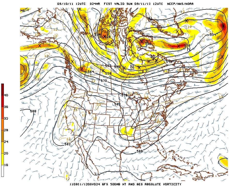 Hightlights Warming trend through the weekend Partly sunny with a small chance of rain Forecast The weekend weather is shaping up to be a nice one! The cut-off low that has been dominating our weather this week with cloudy skies … Continue reading →
 : Cliff Mass Weather Blog This blog provides updated forecasts and comments on current weather or other topics Friday , September 9, 2011 Latest on La Nina A number of you have asked about La Nina and the upcoming winter . nbsp It is always prudent to wait until mid-September before making the call , a call that in any case has considerable uncertainty . nbsp The U.S . Climate Prediction Center has just upgraded the status from a La Nina Watch to a La Nina Advisory--they are basically committing to a forecast of a La Nina winter . nbsp It is not unusual for two La Nina years to occur in a row , although the second one is generally . weaker I don't have to tell you the implications of La Nina for the Northwest--AFTER January 1 it is generally associated with cooler wetter conditions that
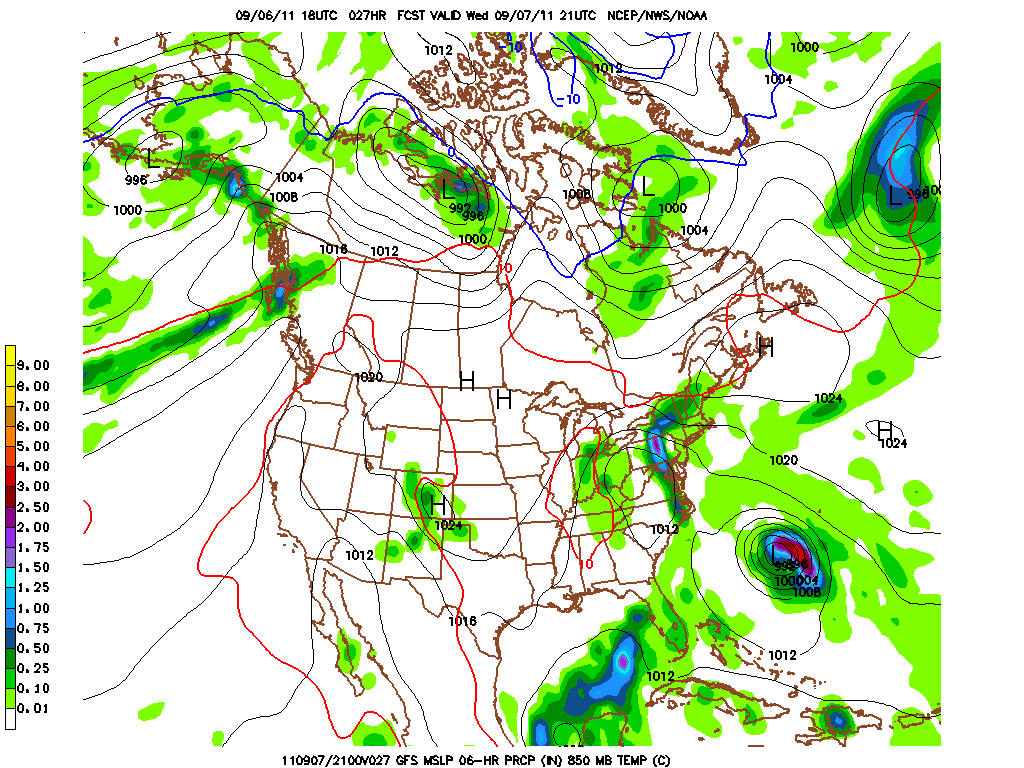 Highlights Upper level low continues to hang over the mid south bringing cool temps and rain chances for the rest of the week. Precipitation should become more scattered in nature tomorrow evening through the rest of the work week. I … Continue reading →
 : Cliff Mass Weather Blog This blog provides updated forecasts and comments on current weather or other topics Monday , September 5, 2011 What is the warmest place on Earth Warmest in the Northwest Perennially chilled Pacific Northwest folks are naturally interested in warmth and so I thought I might share some results of very interesting article in the Bulletin of the American Meteorological Society , which attempts to find the hottest place on earth and here in the NW . nbsp Article is by David J . Mildrexler , Maosheng Zhao , and Steven W . Running of the University of Montana Do a search on the warmest place on earth and you typically get El Azizia , Libya with a record air temperature at 2 meters of 136F measured in 1922. Furnace Creek in Death Valley National Park comes close 134.1F