
Warm Tomorrow
Updated: 2011-04-30 18:30:00
 : skip to main skip to sidebar Cliff Mass Weather Blog This blog provides my latest forecast or comments on current weather or other topics Saturday , April 30, 2011 Warm Tomorrow Today will be a transitional day with low clouds slowly burning off and few residual showers see satellite pic Want sunny skies for sure Head just east of the Cascade crest and down into eastern Washington . The air is still cold aloft so we could get some instability and cumulus development , but that will be increasingly suppressed by high pressure building . aloft Here is the upper level 500 mb for tomorrow strong ridging over us and ridges are associated with sinking motion , which works against cloud . formation With strong sun the intensity today is like mid-August and warming temperatures aloft as the
 When those thunderstorms formed that spawned the deadly tornadoes across the south earlier thsi week formed, some of them reached incredible heights over 50,000 feet tall -- thats' nearly 10 miles high!
I went and found a satellite loop of the storms as they erupted across the south. The loop spans April 27 and into April 28.
Some cloud detail fades in and out on the loop between daylight and nighttime -- I think this is a composite of both infrared and visible satellite imagery.
When those thunderstorms formed that spawned the deadly tornadoes across the south earlier thsi week formed, some of them reached incredible heights over 50,000 feet tall -- thats' nearly 10 miles high!
I went and found a satellite loop of the storms as they erupted across the south. The loop spans April 27 and into April 28.
Some cloud detail fades in and out on the loop between daylight and nighttime -- I think this is a composite of both infrared and visible satellite imagery. , , , , , Advanced Search News Weather Traffic Outdoors Entertainment Communities AMNW Inside KATU Family Matters Local Deals Watch : live KATU News AM Northwest Live Traffic Video What 27 s on : nbsp Advanced Search 80 years ago , there was dust in the wind lots of it Tools 0 Comments Email this article Facebook Tweet Digg Print this article Abandoned orchard trees uprooted in strong northeast winds on April 22, 1931. Photo courtesy : NOAA By Scott Sistek Story Created : Apr 21, 2011 at 11:46 PM PDT Story Updated : Apr 21, 2011 at 11:55 PM PDT I have joked during past crazy weather days around here when we've got sun , rain , wind , hail , and even some lightning that if we were playing Weather Bingo about the only square left uncovered would be dust storm . quot Ahh , but 80 years ago
 : , , , Advanced Search News Video Weather Traffic Sports Entertainment Living Communities KOMO 4 TV KOMO Newsradio Local Deals Blogs Radar Satellite School Delays Forecast Maps FAQ Cameras Quakes Links Ski Report Watch live : KOMO 4 TV What 27 s on : nbsp Listen : KOMO Newsradio Police Scanner Advanced Search Stormy weather : Pretty here scary there Tools 0 Comments Email this article Facebook Tweet Digg Print this article By Scott Sistek Story Created : Apr 19, 2011 at 9:45 PM PDT Story Updated : Apr 19, 2011 at 9:52 PM PDT We've had some relatively stormy weather around the Puget Sound region over the past few days , but as usual it pales in comparison to what most of the rest of the nation would count as . stormy YouNews contributor anvizible gmail.com captured the photo above of the
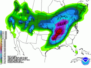 Highlights
-Big Warm-up through Tues.
-Severe weather potential Tuesday Night into Wed.
-Heavy rain not out of the question Tues. night into Wed.
Forecast
As the trough that affected last weekend’s weather moves offshore, a ridge has begun to build across the south and temperatures will rebound under southerly flow with high temperatures on Monday reaching the upper 70’s. Monday [...]
Highlights
-Big Warm-up through Tues.
-Severe weather potential Tuesday Night into Wed.
-Heavy rain not out of the question Tues. night into Wed.
Forecast
As the trough that affected last weekend’s weather moves offshore, a ridge has begun to build across the south and temperatures will rebound under southerly flow with high temperatures on Monday reaching the upper 70’s. Monday [...] 24 previously unseen photographs of the tsunami that struck Japan's northern coast on March 11, 2011. The following images are in no particular order of the events.
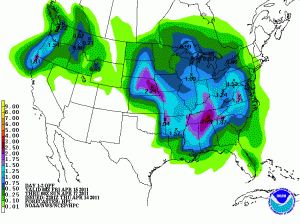 Highlights
• Approaching low pressure system will bring clouds Thursday night
• Severe weather threat on Fri, with more moderate/heavy rain possible.
• Highs in mid 50’s on Saturday, returning to the 70’s by Monday.
Forecast
As convection and severe weather in Oklahoma and Missouri continue overnight, expect high clouds to start streaming into the area overnight. Lows tonight will only get [...]
Highlights
• Approaching low pressure system will bring clouds Thursday night
• Severe weather threat on Fri, with more moderate/heavy rain possible.
• Highs in mid 50’s on Saturday, returning to the 70’s by Monday.
Forecast
As convection and severe weather in Oklahoma and Missouri continue overnight, expect high clouds to start streaming into the area overnight. Lows tonight will only get [...]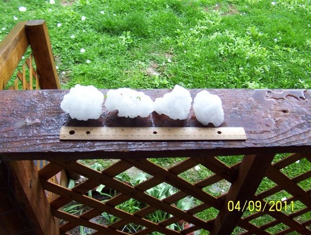 The severe weather threat for Sunday evening / Monday morning advertised earlier this week now appears to be much smaller than initially thought. Both the GFS and the NAM have pushed back the timing of the cold frontal passage to late morning or early afternoon on Monday, and instability is expected to be very limited [...]
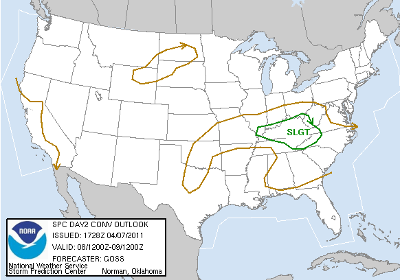 According to the Storm Prediction Center, the Bowling Green area has a chance of seeing severe weather each of the next 3 days. Here’s the convective outlook for tomorrow:
The severe threat tomorrow looks to be marginal. Some degree of instability is forecast to be in place along with moderate wind shear, but upper level ridging [...]
According to the Storm Prediction Center, the Bowling Green area has a chance of seeing severe weather each of the next 3 days. Here’s the convective outlook for tomorrow:
The severe threat tomorrow looks to be marginal. Some degree of instability is forecast to be in place along with moderate wind shear, but upper level ridging [...] , , , , Advanced Search News Weather Traffic Outdoors Entertainment Communities AMNW Inside KATU Family Matters Local Deals Stay Connected : Watch : live KATU News AM Northwest Live Traffic Video What 27 s on : nbsp Video YouNews Promotions Advanced Search Help Victims of Japan's Earthquake and Tsunami There is rhyme and reason to weather forecast terms Tools 0 Comments Email this article Facebook Tweet Digg Print this article By Scott Sistek Story Created : Apr 4, 2011 at 6:11 PM PDT Story Updated : Apr 5, 2011 at 9:29 AM PDT Sometimes a forecast is for scattered showers . Then there is isolated showers and numerous showers Are we just pulling names from a hat Actually , no at least , not where the National Weather Service is concerned . When you look at a National Weather Service-issued
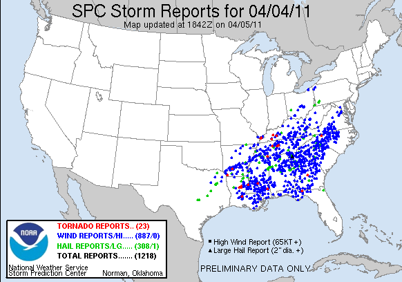 As expected, a large severe weather outbreak took place over the southeastern U.S. yesterday. However, it turned out to be even bigger than expected, with over 1,200 instances of severe weather reported between 7 AM CDT Monday and noon today. Most of these reports were of damaging winds associated with a huge squall line that [...]
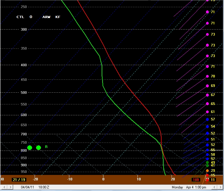 Summary:
-Severe weather possible in the early afternoon hours tomorrow
-Damaging winds currently expected to be the main threat
-Cooler temperatures tomorrow night and Tuesday
A strong upper-level trough will eject out of the Rockies tomorrow, leading to the development and intensification of a surface low pressure center in the the Upper Midwest. This will drag a strong cold [...]
Summary:
-Severe weather possible in the early afternoon hours tomorrow
-Damaging winds currently expected to be the main threat
-Cooler temperatures tomorrow night and Tuesday
A strong upper-level trough will eject out of the Rockies tomorrow, leading to the development and intensification of a surface low pressure center in the the Upper Midwest. This will drag a strong cold [...]