
Monday AM
Updated: 2011-02-28 15:02:00
 : skip to main skip to sidebar Cliff Mass Weather Blog This blog provides my latest forecast or comments on current weather or other topics Monday , February 28, 2011 Monday AM The most extensive precip is south of the city , but some strong bands to the north . Light snow last hour at Sea Tac in the southern band , and Port Angeles and Friday Harbor in the northern features . Too warm for snow at sea level--Sea Tac is at 452 feet . In heavy precip , the snow level can descend to the surface . Hard to get snow to the surface in strong onshore flow . even cold flow like this . unless you have sufficiently intense . precipitation The mountains are just getting pummeled . Posted by Cliff Mass Weather Blog at 7:02 AM 3 comments : Ferdi said . We actually got a light lumpy covering in the wee
 Here’s the latest map from the Storm Prediction Center. They have placed all of Alabama under a slight risk of severe weather, where the threat of large hail, damaging winds and isolated tornadoes exist today. A moderate risk of severe weather is in place over the Tennessee Valley, where several tornadoes are likely. I think [...]
 I’ve got some better news in terms of our severe weather threat for tomorrow. The new soundings are out, and a strong cap is in place. A cap basically keeps convection from naturally forming, as it acts as a block in the atmosphere. Since the cap is a bit stronger than previously expected, we aren’t [...]
 We’re getting into our spring severe weather season, and it’s already beginning on an active note. After Thursday night’s severe weather, now more severe weather is possible on Monday; in-fact, the storm prediction center has placed most of Alabama under a slight risk of severe storms, with a moderate risk over the northern 1/4th of [...]
 A good Friday to you! There’s no doubt many of you were woken up by strong winds, heavy rain and some lightning last night, as a line of powerful storms worked across the state. There were numerous reports of damage across our area, with the most extensive tree and power line damage coming from areas [...]
 The National Weather Service compiled a great list of snow totals from the Feb. 23 storm. We also had an unofficial reports of 36" n Darrington, 24" n Burlington and 12" in Sedro-Woolley.
 The squall line is through Tuscaloosa and downtown Birmingham. There are numerous severe thunderstorm warnings along the line, where there are all kinds of reports of wind damage. Winds will gust 50 to 70 MPH along the line across all of central AL. The line will be through Linden, Marion and Centreville by 1am. The [...]
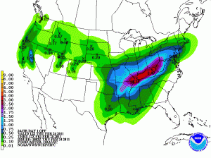 Highlights:
-Major rainmaker on tap for Thursday
-Cooler temperatures on Friday
-Active pattern setting up for next week
Forecast:
Warm front will move north past Bowling Green early Thursday Morning, bringing warmer temperatures and raising dew points. Moisture will be streaming northward in front of a center of low pressure that will deeping in Oklahoma. By noon this front will [...]
Highlights:
-Major rainmaker on tap for Thursday
-Cooler temperatures on Friday
-Active pattern setting up for next week
Forecast:
Warm front will move north past Bowling Green early Thursday Morning, bringing warmer temperatures and raising dew points. Moisture will be streaming northward in front of a center of low pressure that will deeping in Oklahoma. By noon this front will [...] The National Weather Service compiled a great list of snow totals from the Feb. 23 storm. We also had an unofficial reports of 36" n Darrington, 24" n Burlington and 12" in Sedro-Woolley.
 February 22 featured snow, rain, hail, lightning, graupel, sleet, and even a funnel cloud.
The funnel cloud (above) was captured by Jesse Noll of Puyallup.
Most of the fireworks were due to a raging Puget Sound Convergence Zone, which features a collision of north and south winds that wrap around the Olympic Mountains.
Lucky for us, on Tuesday the zone's playground was right over the time lapse camera situated at the University of Washington's Atmospheric Sciences building.
This camera is facing south toward Montlake and the Arboretum. Watch as the clouds both roll north and south -- at the same time! There are some west winds in there too. Crazy day to go flying!
February 22 featured snow, rain, hail, lightning, graupel, sleet, and even a funnel cloud.
The funnel cloud (above) was captured by Jesse Noll of Puyallup.
Most of the fireworks were due to a raging Puget Sound Convergence Zone, which features a collision of north and south winds that wrap around the Olympic Mountains.
Lucky for us, on Tuesday the zone's playground was right over the time lapse camera situated at the University of Washington's Atmospheric Sciences building.
This camera is facing south toward Montlake and the Arboretum. Watch as the clouds both roll north and south -- at the same time! There are some west winds in there too. Crazy day to go flying!
 Highlights:
-Warm air and southwesterly flow bringing in higher temperatures
-Chance of showers increasing through the day on Monday.
-Cooler temperatures on Tues.
Discussion:
After warm frontal passage on Sunday, southwesterly flow will continue into Monday bringing with it some Gulf of Mexico moisture and a good chance of showers. A low pressure system will move across Indiana Monday night, [...]
Highlights:
-Warm air and southwesterly flow bringing in higher temperatures
-Chance of showers increasing through the day on Monday.
-Cooler temperatures on Tues.
Discussion:
After warm frontal passage on Sunday, southwesterly flow will continue into Monday bringing with it some Gulf of Mexico moisture and a good chance of showers. A low pressure system will move across Indiana Monday night, [...] With the crazy weather this week between thunderstorms to kick off the week and chances of lowland snow in the latter half of the week, one person asked how come forecasts from different vary when "we're all looking at the same charts?"
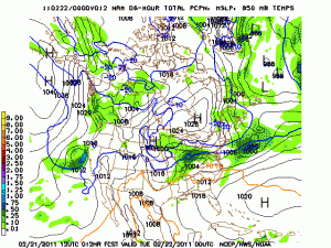
 Louie Grasso and Jeff Braun 8.5 um channel will be new in the upcoming GOES-R ABI. Channel differencing between 8.5um and 12.3um, for example, can be used to differentiate between thin cirrus and low level liquid water clouds. Because this … Continue reading →
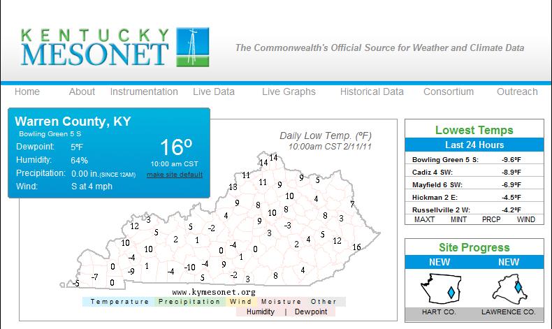 Last week proved to be a very cold and snowy one in the Bowling Green area, with near-record lows and two separate accumulating snowfall events. First, on Monday, morning rain quickly changed to wet snow as a surface low passed just southeast of the area. This event produced 2.1 inches of snow in Bowling Green, [...]
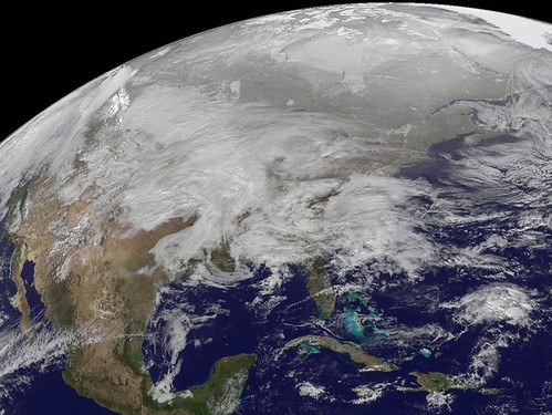 After all, they did leak the iPhone4 months before it was officially announced by Steve Jobs. Maybe they know something about this storm meteorologists dont know. Today they are talking about the big weather event that is affecting much of the central US today and will affect the northeast US tomorrow. As of this morning [...]