They be bubbling already!
Updated: 2011-08-31 17:54:22
 I can still get come geeking in before work.
 I can still get come geeking in before work.
 The polish fest will start on Thursday and last through Sunday. Here are the pieces going into place. See the full gallery on Posterous
 We went out to eat.
 For all of the years I have lived in and around Gaylord, I've never attended the Fair. Now, because of a longer story I won't tell here, Mary and her friend Liz, have inherited the Avon booth at the fair. Tonight, we are setting it up.
 I got a chance to change with Ethan and Dylan the other day. We went to the park in Gaylord at S. Maple School, since Mary and Trisha were at an Avon meeting in town. It was a good time with me teaching a science lesson about static electricity.
  : Cliff Mass Weather Blog This blog provides updated forecasts and comments on current weather or other topics Tuesday , August 30, 2011 Fog Season and Fox News Well , if hurricanes are on one side of the meteorological spectrum , what is on the other Recent fog picture courtesy of the Seattle Times You guessed it . fog , and folks the Northwest is entering fog season . nbsp In fact , September and October are the foggiest time of the year around here , NOT the middle of the . winter On Sunday I got to experience fog first hand--I was heading to Bellingham to do some kayaking near Lummi Island Elakah kayak Seattle was densely fogged in , but every time we gained a few hundred feet elevation on I5 we escaped the shallow fog . This was quite shallow stuff . a few hundred feet at most . nbsp
 Here’s the latest 0Z run of the NAM, which is valid for Saturday morning. For everyone who has plans for the Alabama Football game on Saturday, I’m sure you’ll be paying close attention to the forecast. If the NAM is right, rain bands would start moving into south Alabama Saturday morning but should not threaten [...]
 A good Tuesday to you! After a nice start to the day, it’s much hotter this afternoon. Many folks are feeling temperatures near 100 degrees. As of 4 PM, Tuscaloosa is at 99 degrees. Radar and satellite is very quiet this afternoon, so don’t expect any rain through the rest of the day. In-fact, rain [...]
 Tropical Storm Katia has formed in the Atlantic this morning and afternoon. Katia is becoming better organized and will likely become a major hurricane in 5 days. This storm doesn’t look like a gulf threat at this point. Here’s the latest from the National Hurricane Center. EAST-NORTHEASTERLY SHEAR OVER KATIA HAS DECREASED AND THE STORM CONTINUES [...]
 We’re watching data close this afternoon, as models are indicating tropical development on Wednesday and Thursday. Above is the 18Z run of the NAM for Thursday night at midnight. This shows a developing tropical storm, moving in the direction of Texas. Data is picking up on a tropical wave in the Caribbean. We have a [...]
 A good Monday to you! Today is the anniversary of catastrophic Hurricane Katrina. Be sure to scroll down for thoughts on that. Temperatures this morning were fairly cool, as we have a dry, north flow. Dry air heats and cools very effectively, so a cool start to the day ended up hot this afternoon. Temperatures [...]
 It was 6 years ago today, when we were watching the destructive Hurricane Katrina move inland into east Louisiana and south Mississippi. Later today, Tuscaloosa would experience winds gusting between 60 and 80 MPH. It was a hurricane that I’ll never forget in a season that seemed unreal. Katrina became one of the most powerful [...]
 The National Hurricane Center in their latest tropical update gives Invest 92 a near 100% chance of becoming a tropical cyclone during the next day or two. The hold up is it forming a good center of circulation. That is was distinguishes a tropical depression from a tropical wave. The disturbance is located about 400 miles south [...]
 In the 7pm update the National Hurricane Center gave Invest 92 a near 100% chance of becoming a tropical cylcone in the next 48 hours. Showers and thunderstorms have continued to become better organized this evening. The low pressure system is located about 400 miles south of the southern Cape Verde Islands. Environmental conditions appear [...]
 As I discussed last night Invest 92L has now formed a center of circulation making it Tropical Depression 12 and it is forecast to become Tropical Storm Katia later today. As of right now i appears that this system will stay out in the Atlantic, but long term models take it close to the east [...]
 The Southeast continues under the same pattern as yesterday. An upper level trough over the eastern U.S. with a ridge in place over the Rockies. This will leave the region in a northwesterly flow allowing dry air to continue to filter into our area. This setup will remain over West Alabama for the next day [...]
 : Cliff Mass Weather Blog This blog provides updated forecasts and comments on current weather or other topics Saturday , August 27, 2011 Hurricane Irene Forecasts and Their Hurricanes Versus Our Hurricanes The media is hitting Hurricane Irene really hard and some descriptions are going too far : historical storm storm of the century etc . nbsp Folks , this a category 1 storm with sustained winds of 85 mph . nbsp Serious , but not catastrophic . nbsp We are already seeing local authorities overreact--like NYC cutting off bus and subway service at noon EDT . nbsp At that time the winds at NY's Kennedy Airport were 8 miles per hour and there are only a few showers around . nbsp The strong stuff will not happen until tonight , so why cripple people's ability to move around and for coastal
 : Cliff Mass Weather Blog This blog provides updated forecasts and comments on current weather or other topics Thursday , August 25, 2011 Mid-Level Convection Yesterday was quite a meteorological treat , with interesting clouds and an amazingly colorful sunset . nbsp But it was also a good example of mid-level instability--when the mid-levels of the atmosphere starts to break out into cumulus-like convective . features Yesterday , a weak upper level disturbance was approaching , with upward motion aloft , producing an unstable layer above the . surface One sign of the upward motion was the development of cirrus , include some impressive fallstreaks made of ice crystals Several of you sent me pictures you took of this beautiful feature and several others were shown on the web see example
 : Cliff Mass Weather Blog This blog provides updated forecasts and comments on current weather or other topics Tuesday , August 23, 2011 A Potential Breakthrough in Hurricane Forecasting If you are a billionaire , a foundation leader , a powerful politician , or have a few million dollars to spare , I have an idea for you , one that might greatly improve the skill of hurricane forecasts . nbsp No pressure--just a chance to make a huge difference in predicting storms that do billions of dollars of damage a year . But first lets talk . hurricanes Today , Hurricane Irene is heading for the southeast coast of the U.S . and the current predictions of the National Hurricane Center suggest that the storm will make landfall either on the Outer Banks of North Carolina or New England or both The
 The new coastal radar is scheduled to be officially put in service in about five weeks (Sept. 30) but it's already giving a sneak peek at how it'll be a much bigger help to forecasters.
The National eather Service Seattle office said Monday it was using some of the test data from the radar to help issue a urban flooding advisory for the coast.
Here is the whole article that crossed on the P:
----
The new coastal radar is scheduled to be officially put in service in about five weeks (Sept. 30) but it's already giving a sneak peek at how it'll be a much bigger help to forecasters.
The National eather Service Seattle office said Monday it was using some of the test data from the radar to help issue a urban flooding advisory for the coast.
Here is the whole article that crossed on the P:
---- : Cliff Mass Weather Blog This blog provides updated forecasts and comments on current weather or other topics Monday , August 22, 2011 The New Coastal Radar Delivers A major change in weather is now occurring , with marine air pushing into western Washington , displacing the warmth of yesterday . nbsp A front is approaching the coast , but will it rain How strong is the front Now we know--because of the new coastal . radar This morning , Brad Colman , Meteorologist in Charge of the National Weather Service Seattle office , kindly sent me this image at 7:17 AM they are getting the radar in real-time on many days You can see a strong front offshore , stretching to beyond the Oregon border yellow and red are heavy rain Here is an image two hours later Courtesy of Kirby Cook , Science and
 : Cliff Mass Weather Blog This blog provides updated forecasts and comments on current weather or other topics Saturday , August 20, 2011 The Northwest Drought There have been a lot of complaints about our summer weather , but one thing you have to admit--it has NOT been very wet . nbsp Northwest summers are supposed to be relatively dry , but the last 4-weeks have been downright arid around here . even after we got through the climatologically dry period of the last week of July and first week of . August Here are the precipitation traces for the past four weeks of a line of stations across the State , with the normal shown by the blue . lines All are way below normal , with virtually no rain the last three weeks . nbsp Sea Tac has had about 15 inches and Spokane nothing . nbsp Week after
 : Cliff Mass Weather Blog This blog provides updated forecasts and comments on current weather or other topics Thursday , August 18, 2011 Strong Sound Breeze and Tragedy Last night's 11 PM news and today's Seattle Times related a story about the tragic death of a young man near Seward Park who had been using a Yamaha personal water craft . nbsp The ST article is found here In this article there was a brief mention of a sudden increase in wind and choppiness of Lake . Washington Was there a meteorological origin to this terrible incident If so , could it have been predicted I think I caught a piece of whatever happened while bicycling home around 6:30 PM from the UW-- not far from NOAA Sand Point I was impressed by the strength of the head wind out of the north . nbsp It was really strong .
 : Cliff Mass Weather Blog This blog provides updated forecasts and comments on current weather or other topics Wednesday , August 17, 2011 Bogus Arguments of Some Global Warming Deniers During the past week I have gotten several emails from folks who said they had absolute proof that human-induced global warming is . nonsense The argument they offer : nbsp volcanoes put out way more CO2 than human activities . So it doesn't matter what we do Since I have heard this claim at least a dozen times during the past few months , I thought I should just give the facts : nbsp HUMANS EJECT WAY MORE CO2 INTO THE ATMOSPHERE EVEN DURING MAJOR VOLCANO . YEARS A number of studies have shown that global volcanic activity injects about 0.15 to 0.26 gigatons per year of CO2. Anthropogenic CO2 emissions
 : Cliff Mass Weather Blog This blog provides updated forecasts and comments on current weather or other topics Monday , August 15, 2011 The Upcoming Week AND What Have We Been Missing I just took a look at the latest model output and it appears that we have a fairly decent week ahead . nbsp In fact , the Climate Prediction Center's 6-10 day forecasts have a different look than we are accustomed : to Higher odds for warmer than normal in the West including us near normal over the middle of the U.S . and cooler in the . East The persistent West Coast troughing has weakened and we have fairly normal weather for the entire week . nbsp That means dry and temps getting up into the mid-70s . nbsp Just perfect for painting your house which I just did But something has been missing this year . nbsp
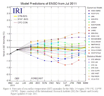 : Cliff Mass Weather Blog This blog provides updated forecasts and comments on current weather or other topics Wednesday , August 10, 2011 Fears of a Double Dip Nothing terrifies Northwesteners more . nbsp Many of us have suffered greatly because of it . nbsp Folks are depressed over its effects . nbsp Supposed experts are not sure which way it will go . nbsp And the media can't seem to get enough of it , with headlines and articles describing its unpleasant effects all the . time The nation's financial mess Political paralysis in Washington D.C . No . I am talking about the threat of . dare I say it the return of La Nina next winter . nbsp Or to use a technical term : nbsp a double-dip La Nina I know , we suffered from La Nina last winter and this spring , and the forecasts were for an
 , , , , , News Weather Traffic Outdoors Entertainment Communities AMNW Inside KATU Family Matters Local Deals Watch : live KATU News AM Northwest Live Traffic Video What 27 s on : nbsp New coastal radar turned on , now in testing phase Tools 0 Comments Email this article Facebook Tweet Digg Print this article The new coastal radar dome is seen after its installation on Friday , May 27, 2011. Photo : National Weather Service By Scott Sistek Story Created : Aug 8, 2011 at 1:12 PM PDT Story Updated : Aug 8, 2011 at 1:14 PM PDT Christmas is still several months away but for local meteorologists , you might as well start the carols as our biggest gift in ages is about to be . unwrapped The National Weather Service announced Monday that they have turned on our new fancy radar on the Washington
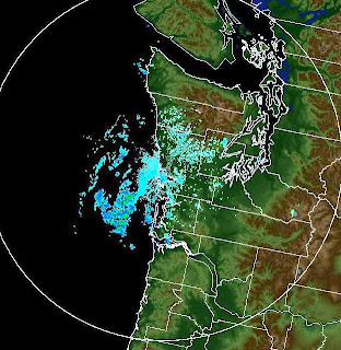 : Cliff Mass Weather Blog This blog provides updated forecasts and comments on current weather or other topics Monday , August 8, 2011 A New Chapter In Pacific Northwest Weather Forecasting With all the depressing news these days , some good news is more than welcome . nbsp And I have very good news : nbsp some important Northwest weather history was made last : week the new coastal radar was turned on and we have received some of the first images After nearly twenty years of local lobbying for this device , it is now a reality . nbsp Lets not beat around the bush . nbsp Here is one of the first images from the new Langley Hill radar , showing conditions around 7:38 AM on Wednesday August 4. This is from the lowest scan 5 degree above the horizontal The clutter suppression capabilities are
 : Cliff Mass Weather Blog This blog provides updated forecasts and comments on current weather or other topics Friday , August 5, 2011 Aurora There is a significant chance you can see an aurora around here tonight---assuming you can get away from the infernal low . clouds There was a major solar storm yesterday and the impact is starting to be felt today in the earth's upper atmosphere . Here is a plot from the NOAA Space Weather Prediction Center SWPC You can see the jump in the proton flux yesterday and if you look at the estimated Kp on the fourth line down a measure of the disturbance of the earth's magnetic field we have a fairly major event estimated Kp values of around 8 The SWPC has a handy map in which they estimate how far south the aurora will go relative to the Kp number . nbsp