
: Cliff Mass Weather Blog This blog provides updated forecasts and comments on current weather or other topics Wednesday , June 12, 2013 Rainier's Shadow Mount Rainier is perhaps the most famous landmark in our state . and it can cast the most amazing shadows . nbsp This morning with a relatively uniform cloud deck that topped out around 6500 ft , the mountain's shadow was quite evident . For example , the 5:30 AM visible satellite image clearly showed Rainier's shadow and that of Mt . . Adam And during the next hour or so , it quickly . shortened And , of course , if there is a higher level cloud deck the shadow can appear on the bottom side of the clouds , as illustrated by the next two . pictures Chuck Graham captured the upper photo from nearby Roy , . Wash If aliens arrived at our

 It is with great sadness this morning that we have learned three well known and highly respected storm chasers have lost their lives while chasing near El Reno, Oklahoma on Friday. Tim Samaras and his son Paul, and Carl Young were killed by the wedge tornado that occurred on Friday.
 Tour 2 intercepts tornadoes near Granbury, Texas
 : Cliff Mass Weather Blog This blog provides updated forecasts and comments on current weather or other topics Saturday , June 29, 2013 Eastern Washington Gets Hit Hard By Strong Thunderstorms Saturday was an amazing day over and east of the Cascade crest with numerous very strong thunderstorms , particularly along the eastern Cascade slopes . nbsp Large hail , strong winds and heavy rain hit from Yakima to Wenatchee , with some observers describing dime or quarter size hail . nbsp Strong winds have downed trees and powerlines , and localized flooding has occurred see picture from Ellensburg below Downtown Ellensburg : nbsp Picture Courtesy of Stephers Another picture by Stephers . but NOT a tornado . Rather a heavy rain shaft descending from a large convective system And for me there was
 The frontal boundary responsible for our bouts of rain and thunderstorms finally pushed south of our viewing area earlier this evening. If you live south of I-20, you may have had a downpour or two in your backyard this afternoon, but the rain showers for our viewing area have diminished. As a result, we’ve had […]
 Good Friday evening! After two rounds of strong to severe storms across Alabama, our weather has gone quiet as of 10:25pm. Storms have ended across all of west and central Alabama, but we are still expecting a lone storm or two on radar tonight. Most areas will stay rain free. Expect lows in the lower […]
 THE NATIONAL WEATHER SERVICE IN BIRMINGHAM HAS ISSUED A * SEVERE THUNDERSTORM WARNING FOR… HALE COUNTY IN WEST CENTRAL ALABAMA… * UNTIL 800 PM CDT * AT 715 PM CDT…THE NATIONAL WEATHER SERVICE INDICATED A SEVERE THUNDERSTORM CAPABLE OF PRODUCING QUARTER SIZE HAIL…AND DESTRUCTIVE WINDS IN EXCESS OF 70 MPH. THIS STORM WAS LOCATED NEAR […]
 THE NATIONAL WEATHER SERVICE IN BIRMINGHAM HAS ISSUED A * SEVERE THUNDERSTORM WARNING FOR… SOUTHWESTERN TUSCALOOSA COUNTY IN WEST CENTRAL ALABAMA… * UNTIL 615 PM CDT * AT 529 PM CDT…THE NATIONAL WEATHER SERVICE INDICATED A SEVERE THUNDERSTORM CAPABLE OF PRODUCING PING PONG BALL SIZE HAIL. THIS STORM WAS LOCATED NEAR JENA…OR 13 MILES SOUTH OF GORDO…AND […]
 As of 5:20pm, we’re watching new storms form on a cold front across west Alabama. The cold front is moving through Lamar, Winston and Cullman County at this point. As the front continues to track south, storms will continue to develop ahead of the front over the next few hours. If a storm moves over […]
 Good Friday afternoon! As of 2:15pm, there is no longer a severe thunderstorm watch over our area. The first complex of storms that developed over northwest Alabama this morning, has shifted into the Montgomery area this afternoon. At this point, there are no additional storms over west or north Alabama. As things heat up this […]
 : Cliff Mass Weather Blog This blog provides updated forecasts and comments on current weather or other topics Friday , June 28, 2013 How Bad Will The Heat Wave Be There are some interesting elements about the upcoming Northwest heat wave that I wanted to . share This is NOT going to be an historic heat wave west of the Cascades . but we could well break a daily high temperature record on Monday . nbsp So don't expect the high 90s , with peaks about 100F , that we experienced in late July 2009. And there is a chance of some major thunderstorms . but just a . chance So why will this event be modest The reason is that the set-up is not correct for one of the big events , because the low-level pressure distribution will be wrong and we won't have sustained offshore flow . nbsp Specifically ,
 Good Friday morning! As of 11:30am, there is now a severe thunderstorm watch for areas south of I-20 until 8pm this eve. A batch of severe storms have developed over west and central Alabama at this hour, with the main risk being wind damage. Severe storms are located on the south side of I-20 over […]
 As of 10:15pm, a few storms have developed on radar. These storms were lined up from Tupelo to Reform to Holt Lake to Clanton to Alexander City. This is a broken band of storms, so not everyone will get rain as they drift south southeast. Expect lots of lightning if the storms move over your […]
 Good Thursday afternoon! It has been a very hot summer-like day, with highs in the lower to middle 90s. At one point, the heat index was nearing 110 across parts of west Alabama. A ridge of high pressure has kept much of the south hot, but the core of the ridge is west of Alabama. […]
 : Cliff Mass Weather Blog This blog provides updated forecasts and comments on current weather or other topics Wednesday , June 26, 2013 Major Warm Up Ahead The past several days has brought strong showers , lightning , and occasional gusty winds . nbsp But that inclement weather will soon be a memory as a major ridge develops over the western U.S . nbsp Temperatures will climb into the 80s west of the Cascades , with highs reaching into the lower 100's early next week over portions of eastern . Washington The latest 6-10 day temperature forecast from the Climate Prediction Center says it all : nbsp well above normal in the west , with the most anomalous warmth dark red over eastern Washington and . Oregon The origin of both our current cool wet pattern and this weekend's warmth is
 : Cliff Mass Weather Blog This blog provides updated forecasts and comments on current weather or other topics Monday , June 24, 2013 Cosmic Errors You are a high administrator in NOAA the National Oceanographic and Atmospheric Administration or a Senator Congressman on a committee overseeing . NOAA You know that , due to mismanagement , the U.S . weather satellite program is in trouble and a key satellite program the polar orbiters may not be ready before a current satellite . fails You know such a gap in coverage could have have very serious impacts on the skill of our weather prediction models and of other nation's as well You know there is currently a highly , successful , cost-effective satellite system COSMIC that uses the bending of GPS signals in the atmosphere GPS to produce huge
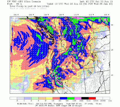 : Cliff Mass Weather Blog This blog provides updated forecasts and comments on current weather or other topics Saturday , June 22, 2013 The Upcoming Northern Californa Summer Deluge A highly unusual summer deluge will soon hit northern California . nbsp June is typically quite dry over the Golden State it isn't called golden for nothing A climatological 1980-2010 precipitation map see below tells the story . from the Bay area south and west the monthly totals are 1 to 4 inches and even the northern Sierra Mts . only typically receive about an inch . But take a look what the models are now consistently forecasting for the 48 h ending 5 AM on Wednesday : 1-5 inches over the northern Sierra the pink and black colors and 5 to 1 inches for much of the remainder of northern CA . nbsp We won't
 By Ken Pryor (NESDIS), Dan Bikos (CIRA) and Scott Lindstrom (CIMSS) During the early afternoon of 10 June 2013, a cluster of convective storms developed over the front range of the Rocky Mountains of Colorado and then tracked eastward over … Continue reading →
 : Cliff Mass Weather Blog This blog provides updated forecasts and comments on current weather or other topics Monday , June 17, 2013 Summer Thunderstorms An area of summer thunderstorms and cumulus convection is moving through tonight , and for many of you this is the first rain in . weeks Let's look at recent radar imagery every two . hours 5 PM : nbsp lots of showers on the coast and . offshore 7 PM : nbsp the coastal showers moved inland and substantial thunderstorms hit eastern . WA 9 PM : nbsp Puget Sound gets moistened and a very heavy show red color is moving through south of Yakima The 12-h totals as of 9 PM , modest precipitation is found around the region . nbsp Few hundredths to a few tenths in . general The cause The classic NW convection pattern . nbsp A trough or low off the
 : : Cliff Mass Weather Blog This blog provides updated forecasts and comments on current weather or other topics Saturday , June 15, 2013 Halos and contrails : Is there a connection The short answer is YES Today I received pictures from several of you regarding some wondrous halos in the sky . nbsp Others noted an impressive collection of contrails . and there is no accident that both apparitions appeared at the same time : nbsp the ultimate cause is the . same Here is a very nice picture from Brendan Fields showing both appearing at the same time And from Jules submitted to the Seattle : Times A high resolution MODIS image from today shows an extensive collection of high cirrus and cirrostratus clouds and if you look carefully you will see lines : nbsp those are contrails Halos occur when
 : Cliff Mass Weather Blog This blog provides updated forecasts and comments on current weather or other topics Monday , June 10, 2013 Using Unmanned Aircraft for Severe Thunderstorm Prediction and Warning After the tornado outbreaks in Moore City and Oklahoma City , Oklahoma , there was a flood of controversy about the role of storm chasers . nbsp With the tragic loss of three experienced storm chaser scientists , the injury of the several Weather Channel chasers see picture below of their car and the veritable traffic jam of chasers in the immediate vicinity of the Oklahoma City tornado see image a number of observers have suggested that there must be a better way of observing . tornadoes Furthermore , when a severe thunderstorm pops up in an unexpected location and this happens plenty of
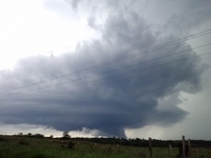 Day 12 started off with a forecast discussion in Weatherford, OK. There was a moderate risk issued for parts of south central Oklahoma into central Kansas. The original target was for Stillwater, OK. All of the needed ingredients stacked up over that area. We had plenty of synoptic scale lifting from the upper level winds. [...]