
A Strange Warm Rain
Updated: 2013-01-31 06:00:00
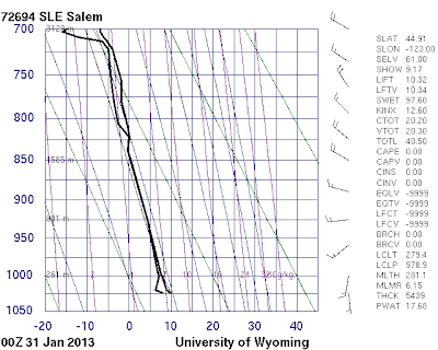 : Cliff Mass Weather Blog This blog provides updated forecasts and comments on current weather or other topics Wednesday , January 30, 2013 A Strange Warm Rain 3 PM View In Seattle Today was a day of warm , light drizzle from sunrise to sunset . nbsp Visibility was minimal and air was permeated by an ethereal mist . nbsp Biking home in the drizzle tonight on the dark Burke Gilman trail , I could not remember when I had less . visibility View from the KIRO Tower Cam . you could barely see the ground But although it was drizzling lightly all day , the Camano National Weather Service radar showed nothing for most of the day see example Radar at 3:17 PM How could that be And consider that the origin of the light rain was very different from nearly all of the rain we get here during the .
 Good Wednesday evening! After severe weather issues earlier this morning, conditions are becoming pretty quiet this afternoon and evening. As of 4:30 pm, a batch of showers were moving across parts of west and central Alabama, but most of us are starting to dry out. Conditions will continue to dry out later this evening and [...]
 Good Wednesday afternoon! As of 2:45pm, all severe weather issues were in the state of Georgia; in-fact, things have been pretty quiet over the past several hours across all of west and central Alabama. While it has rained a lot this morning, the severe weather issues didn’t last long early this morning. All we’re left [...]
 Good Wednesday morning! As of 8:50am, severe weather issues have ended for most of west Alabama. While rain is still falling over much of west Alabama at this time, the severe threat is on the leading edge of the rain. As of 8:50am, the damaging wind portion of the storms were located in a line [...]
 Good Wednesday morning! As of 7:30am, the line of strong to severe storms has passed east of Fayette, Jasper, Tuscaloosa, Vernon, Reform, Eutaw and Geiger. Areas east of Livingston, Eutaw, Tuscaloosa and Jasper will still deal with a threat of damaging wind and an isolated tornado over the next couple of hours. This mess should [...]
 Good Wednesday morning! Other than a couple of tornado warnings and severe thunderstorm warnings, we haven’t had that much damage being reported across Alabama so far. The main area of wind damage we picked up was over Fayette and Winston County. Even where we had a couple of tornado warnings, I haven’t heard of any [...]
 Everyone enjoy the warmth this afternoon, because it is all about to change. The front will pass through overnight tonight and with that it is going to bring the chance of severe weather and colder temperatures after the front. The CAPE is slightly higher than previous models have shown, which hints to us more instability [...]
 : Cliff Mass Weather Blog This blog provides updated forecasts and comments on current weather or other topics Monday , January 28, 2013 Fixing the National Weather Service's Computer Gap In previous blogs , I have documented the profound inadequacy of the computational resources used for operational numerical weather prediction by the National Weather Service NWS and the serious implications this deficiency has for the quality of weather forecasts in the U.S . nbsp I have described how the world-leading European Center for Medium Range Weather Forecasting ECMWF now has more than ten times the computer power as the U.S . Environmental Modeling Center EMC how U.S . skill in global prediction is in second or third place , and how the lack of computer resources is crippling the NWS's ability
 I am sure everyone is in the need of a break from the winter weather that we have seen the past couple of days. Well the break is on the way. Temperatures will make their way into the upper 50s and into the 60s this week. This is about 20 degrees above average. But with [...]
 : Cliff Mass Weather Blog This blog provides updated forecasts and comments on current weather or other topics Thursday , January 24, 2013 Superstorm in the Atlantic Although my attention is generally on the Pacific Ocean , I can't help note the weather event that many meteorologists are talking about the last few days : nbsp the development of an extraordinarily intense cyclone in the north Atlantic , a storm much deeper than Hurricane . Sandy The central pressure of Hurricane Sandy dropped to approximately 940 hPa and was huge in size . nbsp The storm that will be revving up tomorrow is forecast to hit roughly 924 hPa by Saturday morning 4 AM PST The is one intense storm . nbsp Here is this morning's forecast of the European Center model made for 4 AM PST on Saturday . nbsp More isobars
 An Arctic airmass over the Great Lakes provided for a significant lake-effect snow event off Lake Ontario leading up to January 23, 2013 (maximum snowfall reports 3 feet near the southeast shoreline). Near the end of this lake-effect snow event, … Continue reading →
 Winter has been in full force here is south-central Kentucky this week. We had the coldest air of the season makes its way into the area for Monday night and Tuesday. We reached a low of 16 at the Bowling Green airport Tuesday morning and only climbed to a high of 28. Thanks to southwesterly [...]
 The nearly 60 degree weather we had on Saturday is all just a distant memory now as much colder air has spilled its way south into the Ohio Valley. Yesterday highs still managed to reach the upper-40s and thus temperatures were still slightly above average. Today however temperatures will struggle to reach the mid-30s and [...]
 : Cliff Mass Weather Blog This blog provides updated forecasts and comments on current weather or other topics Saturday , January 19, 2013 Amazing Contrasts in Maximum Temperatures These are the maximum temps for the 24-h period ending 10 AM on Saturday . nbsp Amazing contrasts . in the fifties some near 60F at locations a few thousand feet above sea level , while it only got into the thirties and very low 40s near sea level . nbsp A number of locations at lower elevations never got above the mid-30s . nbsp It was WAY warmer in Snoqualmie Pass than in . Seattle This is a real inversion I am heading to a local peak this afternoon to enjoy spring-time temperatures and warmth Issaquah Alps and higher hills on the east side will do Posted by Cliff Mass Weather Blog at 10:19 AM Email This
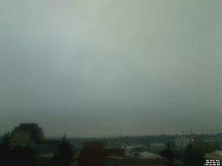 : Cliff Mass Weather Blog This blog provides updated forecasts and comments on current weather or other topics Friday , January 18, 2013 Relief Aloft For many folks in the lowlands of western Washington and Oregon , the day was dismal , dark , foggy , and cold . nbsp Here is an example , taken at 4 PM at the top of my building at the UW in . Seattle But warmth and sunshine was close at hand-- you just needed to gain about 1000 . ft For example , a short drive up to a hilltop 1170 feet in Bellevue brought sun and ethereal views of the cloud layer below pictures courtesy of Peter Banda , taken around 4 PM Want to stay in Seattle Just take the elevator ride to the Columbia Center's observation platform around 1000 ft high as Joseph Chan did : today Amazing pictures . the clouds reached up to
 Since Tuesday night’s ice potential the weather has gotten much calmer with the sun finally deciding to join us again. Luckily during Tuesday night’s system temperatures had a very hard time falling below freezing but rather hover at or just above the freezing mark for most of the event. 1 degree or even just a [...]
 It's the second-most frequent question I get in the weather email box: "What's the difference between a watch and a warning?"
It was enough that I finally wrote an entire blog entry breaking down what the various National Weather Service terms mean so I could just send an email link.
In the current system, for those who don't want to click the hyperlink above, a "Watch" is usually issued 24-48 hours ahead of an approaching event and means conditions are possible, but not a slam dunk. As the event nears, it will get converted to a Warning (severe conditions are imminent or happening) or an Advisory (less severe conditions are imminent or occurring).
It's the second-most frequent question I get in the weather email box: "What's the difference between a watch and a warning?"
It was enough that I finally wrote an entire blog entry breaking down what the various National Weather Service terms mean so I could just send an email link.
In the current system, for those who don't want to click the hyperlink above, a "Watch" is usually issued 24-48 hours ahead of an approaching event and means conditions are possible, but not a slam dunk. As the event nears, it will get converted to a Warning (severe conditions are imminent or happening) or an Advisory (less severe conditions are imminent or occurring).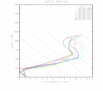 : Cliff Mass Weather Blog This blog provides updated forecasts and comments on current weather or other topics Friday , January 18, 2013 Super Inversion and Bad Air Cold air and foggy conditions have dominated the lowlands on both sides of the Cascades , as shown by visible satellite imagery this afternoon . The irony of all this is that while near sea level the temperatures were in the 20s and 30sF a few thousand feet up it was sunny and in the lower . 50s As you know , such situations in which temperature increases with height are called inversions , since they are opposite to the normal situation of temperature decreasing with height . nbsp Using the capabilities on the SnowWatch web site , here is the temperature variation with height at 5 PM on Thursday--around 50F at 2000 ft and
 : , , , Skip to primary navigation Skip to main content KATU.com Exit Gallery Northwest weather photos : A beautiful start to 2013 Share this story email Share this story « Previous 1 of 45 Photos Next » « Previous Next » « » Gorgeous Sunrise Photo : Mirwais Azami Copyright 2013 Fisher Interactive Network KATU , 2153 N.E . Sandy Blvd . Portland , OR 97232 Contact Us Advertise with Us Media Kit Careers Privacy Policy Terms of Use Public Filing Report Closed Captioning Copyright © 2013 Fisher Communications , . Inc For assistance accessing the Online Public File please : contact Tami Schell at 503-231-4225 ABC Powered by Broadcast Interactive Media
 : Cliff Mass Weather Blog This blog provides updated forecasts and comments on current weather or other topics Wednesday , January 16, 2013 Strange lines over the northeast Pacific The visible satellite imagery over the northeast Pacific Ocean looks very strange today , with weird-looking lines and strange shapes in the clouds . nbsp Take a look at image from 11:15 AM this morning from the National Weather Service GOES weather : satellite You can also see the low clouds over Willamette Valley and the snow in the Sierra Mountains , as well as those infernal lines over the Pacific . nbsp You can get another view of these clouds from the high-resolution MODIS : satellite What are these lines They are commonly called ship track clouds and are produced by the particles emitted by ships that
 As mentioned yesterday we would have to keep a close eye on the temperatures here in south-central Kentucky to see what type of precipitation would fall tonight. Temperatures have risen to 35 at the airport as of 1′oclock Meanwhile the Kentucky mesonet shows temperatures hovering around the freezing mark. The key is that dewpoints are [...]
 After a weekend of warm temperatures and rain we now find ourselves in the low 30s with sleet falling in the area. A very strong cold front blasted its way through the commonwealth yesterday bringing in much colder temperatures. At one time Sunday afternoon temperatures dropped 15 degrees in an hour. The front has since [...]
 As mentioned 11 WKU meteorology/land, weather, climate majors traveled to Austin, TX for the Annual American Meteorological Society (AMS) meeting. Dr. Mahmood, WKU professor of geography/meteorology, also made the trip to Austin with his family to attend the meeting. Students left Bowling Green last Friday morning and after staying the night in Dallas, TX made their [...]
 We’re back! For those that noticed the lack of forecasts this past week it was because 11 WKU meteorology students (including your forecaster) traveled to Austin, TX for the 2013 American Meteorological Society Annual Meeting. I’ll post a recap of the trip later but for now back to the weather. When I last posted, we [...]
 : Cliff Mass Weather Blog This blog provides updated forecasts and comments on current weather or other topics Friday , January 11, 2013 A Dangerous Night Driving home tonight in Seattle around 10 PM , the road conditions were degrading rapidly . lots of ice on the road and I even started to skid in some . places You can see the reflections off the roadway icing near the UW tonight All the ingredients were there . lack of middle and upper level clouds , good radiation cooling to space , near calm surface winds , surface temperatures below freezing , and freezing . fog The 10 PM observations say it all . much of the region away from water is in the mid-20s and winds are light red numbers are temperature , blue numbers are dewpoint So be careful tonight and tomorrow morning and Sunday night
 : Cliff Mass Weather Blog This blog provides updated forecasts and comments on current weather or other topics Friday , January 11, 2013 Sunglasses and Caution If you lost your summer sunglasses , you better find them . nbsp But if you are driving , some caution is advised , since the downside of clear , cold conditions is roadway . icing The freezing level is now hovering around 1000-1200 ft , which means the snow level is around sea level generally it takes about 1000 ft for snow to melt in a layer above freezing So if you are near sea level and precipitation is very light , you can get rain . nbsp But get above a few hundred feet or get hit by harder precipitation , and wet snow will be falling . nbsp A few remnant showers might be around early Friday , but those will be history very
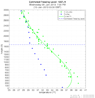 : Cliff Mass Weather Blog This blog provides updated forecasts and comments on current weather or other topics Wednesday , January 9, 2013 Convergence Zone Snow and Colder Weather Ahead We are now about to enter the most sustained period of cold air of the winter so far . nbsp Temperatures aloft have progressively cooled today , with freezing levels right now at around 1600 ft and thus snow levels around 600 ft . nbsp But in heavy precipitation , melting and evaporation can cool the atmosphere further , driving the snow level to the surface . nbsp And the atmosphere should continue to cool over the next few . days This is not a vague threat . moderate precipitation in a Puget Sound convergence zone has started to bring wet snow to the ground from north Seattle up to Everett . tonight If