
: Cliff Mass Weather Blog This blog provides updated forecasts and comments on current weather or other topics Tuesday , August 7, 2012 Amazing Mammatus Announcement : Columbus Day Storm 50th Anniversary Gala at the UW : Oct . 11, 7:30 PM On Thursday evening , October 11 at 7:30 PM , the UW will host a gathering to review and remember the 1962 Columbus Day Storm October 12th will be the 50th anniversary I will discuss the major aspects of the storm and windstorm chronicler Wolf Reed will tell even more . nbsp The Mt . Hebo radar dome broke apart that night as winds gusted above 150 mph , and we will have an eye witness account . nbsp And there will be time for your comments , questions , or stories . nbsp Steve Pool of KOMO TV will MC . nbsp This meeting should be great fun will take place

 There are a few really good storm photos that continue to get recirculated on social networks as the "last big storm event". One of the most dramatic is a Florida waterspout that was captured accidentally by amateur photographer Fred Smith from his back yard near Lake Okeechobee on June 15, 1993.
 Decades of computerized weather and climate data has led NOAA forecasters to predict a warm and dry winter in the Pacific Northwest.
The mystery man behind the Farmer's Almanac winter forecast agrees on the dry part, but not necessarily on the warm part.
Decades of computerized weather and climate data has led NOAA forecasters to predict a warm and dry winter in the Pacific Northwest.
The mystery man behind the Farmer's Almanac winter forecast agrees on the dry part, but not necessarily on the warm part.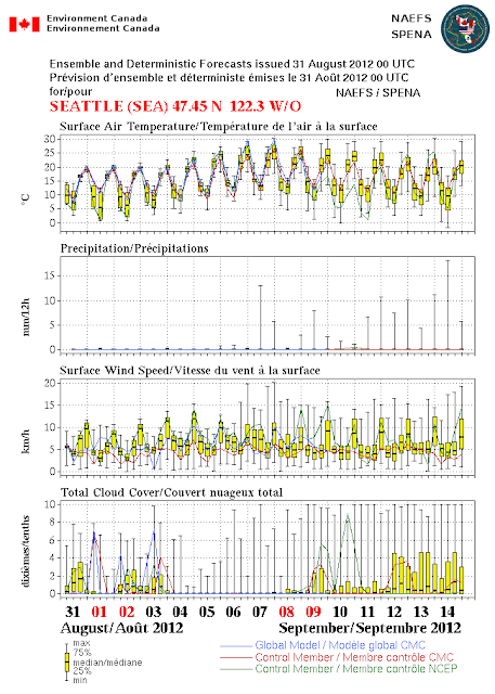 : Cliff Mass Weather Blog This blog provides updated forecasts and comments on current weather or other topics Friday , August 31, 2012 The Driest August In Seattle History and more to come I didn't want to mention this , worrying I might jinx it , but it is clear that August 2012 will the driest in Seattle . history So far we have had a trace which means a sprinkle that is less than 01 inches . The National Weather Service defines measurable rain as rain of 01 inches or more . The previous record was in 1974 when 01 inches had . fallen The other record we working on is the longest stretch of dry days----for which the record is 51 . days Right now we are at 38 days . which I believe is something like the 7th longest dry spell . But it is clear that we have at least 4-7 days of no rain
 Good Thursday evening to you! It’s amazing how many tornado warning were issued in east Mississippi and southwestern Alabama, but the band producing tornado warnings just couldn’t hold together as it tracked eastward. The tornado watch has been canceled for our area tonight. There are only a few light tropical showers out there at this [...]
 Good Wednesday afternoon to you! The weather across the deep south has been very active today due to the large Isaac. The system is moving to the northwest and is slowly pulling away from the New Orleans Area. As the storms moves well inland, it is weakening, so look for the strong winds around Isaac [...]
 Forecast Highlights: 1. Sunny and hot today and tomorrow. Clear tonight. 2. Models continue to depict a strengthening mid-level ridge Thursday night through Friday night over the mid-Atlantic coast extending westward into eastern Kentucky. 3. Still expecting the center of … Continue reading →
 Forecast Highlights: Today: Clearing, sunny afternoon, highs in the upper 80s Tonight: Clear, Lows in the mid 60s Wednesday: Sunny, high 90 This Weekend: 60% chance of rain from Tropical Storm Isaac Hello! Classes are back in session here in … Continue reading →
 : Cliff Mass Weather Blog This blog provides updated forecasts and comments on current weather or other topics Monday , August 27, 2012 The Real Threat of Tropical Storm Hurricane Isaac The media isn't talking about this much , but the real threat of tropical storm Isaac may be heavy precipitation and flooding . not winds and storm . surge Recent model runs suggest the storm might stall over southern Lousiana , resulting in huge amounts of precipitation storm totals of 12-24 inches in some locations Here is the latest storm total precipitation totals form the NWS GFS 78 hr total and NAM 84 hour total models for runs started at 1200 UTC this : morning Pretty impressive . precipitation And here is a nice satellite image of Isaac at 11 AM with some observations plotted . nbsp One report of 70
 : Cliff Mass Weather Blog This blog provides updated forecasts and comments on current weather or other topics Sunday , August 26, 2012 First Frost and Tropical Storm Isaac Nights are getting longer now and with clear skies some locations , particularly east of the Cascades in low spots , are dropping into the 30s and even to . freezing For example , at Turnbull National Wildlife Refuge , southwest of Spokane see map above yesterday morning 25 August there were 3 hours at or below freezing for the surface air temperature taken at 2 meters and a ground surface temperature of 29 degrees : F 25 TRNW1 cn 0600 40 0 TSFC=39 SR=0 25 TRNW1 cn 0700 38 0 TSFC=36 SR=0 25 TRNW1 cn 0800 37 0 TSFC=34 SR=0 25 TRNW1 cn 0900 34 0 TSFC=33 SR=0 25 TRNW1 cn 1000 34 0 TSFC=31 SR=0 25 TRNW1 cn 1100 32 0 TSFC=30
 : Cliff Mass Weather Blog This blog provides updated forecasts and comments on current weather or other topics Monday , August 20, 2012 Midsummer Drought Your plants know it , and so will your water bills if you have a garden . nbsp Over western Washington most places have not seen rain in roughly four . weeks For Seattle , the last day of measureable precipitation at least 01 inch was July 22. For Spokane and Wenatchee , its been dry since July . 20th Are we in a drought now Lets check the latest U.S . Drought Monitor Information for Washington State . nbsp No . problem Most of the region is not in drought , with a little bit of dryness in a small portion of eastern . Washington So how can this be No rain for a month and no drought Because this is pretty much normal for around here . in
 : Cliff Mass Weather Blog This blog provides updated forecasts and comments on current weather or other topics Saturday , August 18, 2012 Escaping the Lightning Bullet The convective band is now passing through the region , and the strongest thunderstorms and most of the lightning passed offshore . nbsp Little lightning over the Cascades and thus only a minor threat of lightning induced fires . some good news for those dealing with . wildfires Here is a recent radar . you can see where the showers : are The next issue will be the return of the northwesterly winds to Cle-Elum Ellensburg . nbsp Take a look at the 4 3 km high resolution UW forecasts for tomorrow AM and tomorrow night . nbsp These are sustained winds . not gusts . The last figure is for 8 PM Sunday night . and the winds will
 : Cliff Mass Weather Blog This blog provides updated forecasts and comments on current weather or other topics Friday , August 17, 2012 New Wildfire Threat The fires around Ellensburg and Cle Elum are now slowly being contained , with a huge assist from the heat wave west of the Cascades . nbsp Ironically , the west-side heat and the associated thermal trough of low pressure has reversed the pressure difference across the Cascades , greatly weakening the strong winds over Kittitas County that allowed the fire to . explode But everything is about to change . and not necessarily for the . better Today clouds have inundated the coast and a shallow veneer of marine air pushed into the western side of the Cascades see satellite picture Friday morning . you can also see some Asian smoke The cool
 : Cliff Mass Weather Blog This blog provides updated forecasts and comments on current weather or other topics Friday , August 10, 2012 Extraordinary Asian Smoke versus the Perseid Meteors Dense smoke from Asian fires has again spread over our region , profoundly degrading . visibility Here is a MODIS satellite view from earlier : today The smoke continues into British Columbia and : Alberta There should be some amazing sunsets in the Northwest tonight from the smoke . nbsp Some of the smoke is mixing down , reducing visibility and air quality near the surface . nbsp Look at the amount of small particles PM2.5 at the Cheeka Peak observatory on the northwest corner of the Olympics see graphic below You can see the big rise in the number of particles . today Yesterday we could see the smoke
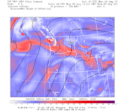 : Cliff Mass Weather Blog This blog provides updated forecasts and comments on current weather or other topics Monday , August 6, 2012 Mid-level Convection Last night there was a weak push of marine air into western Washington that will take the edge off the heat today . nbsp Related to my earlier blog , the thermal trough has moved into eastern Washington , easterly flow over the mountains has ceased , and there is an onshore pressure gradient , pushing marine air inland . nbsp This was not a strong marine push and temps will remain at or a bit above normal . today But something else is going on . a weak upper trough is moving northward through the region , and with relatively unstable air above , we are seeing a line of mid-level convection pass northward across the area . nbsp Here is