
Whitewater-Baldy Fire: Case of the “Disappearing Smoke” – Differences in Visible Smoke Detection – GOES 15 vs GOES 13
Updated: 2012-05-31 18:28:40
 Louie Grasso and Jeff Braun Now: The Whitewater-Baldy Fire is a very large wildfire that has existed over southwestern New Mexico during the last couple of weeks of May and into June 2012. Geostationary satellites can be an excellent tool … Continue reading →
 We woke up in Stillwater Oklahoma after a successful day the previous day with insane structure on storms we witnessed just northwest of Oklahoma city. Storms continued to persist throughout our region along a boundary that was left from the … Continue reading →
 Good Wednesday morning! Much of Alabama is dry, but if you live in Sumter, Greene, Pickens or southwest Tuscaloosa County, you have been dealing with rain most of the night and much of this morning. As of 11:20am, rain is still falling moderate to heavy right along I 20/59 in areas southwest of Tuscaloosa. This [...]
 We’ve got some rain on radar this Thursday morning. I’ll admit this activity is rather unexpected at this 8am hour, but we could use the extra rain. Moderate rain is falling over parts of Sumter, Greene, Hale, Pickens and Tuscaloosa County. This activity is slowly moving northeast. Rain will reach the Tuscaloosa and Northport area [...]
 Good Wednesday evening to you! The threat of severe storms is looking fairly high Thursday evening through early Friday morning. While severe storms are likely, I don’t expect much of a tornado threat. The main area of wind shear and dynamics will pass north of our area. The main threat will be in the form [...]
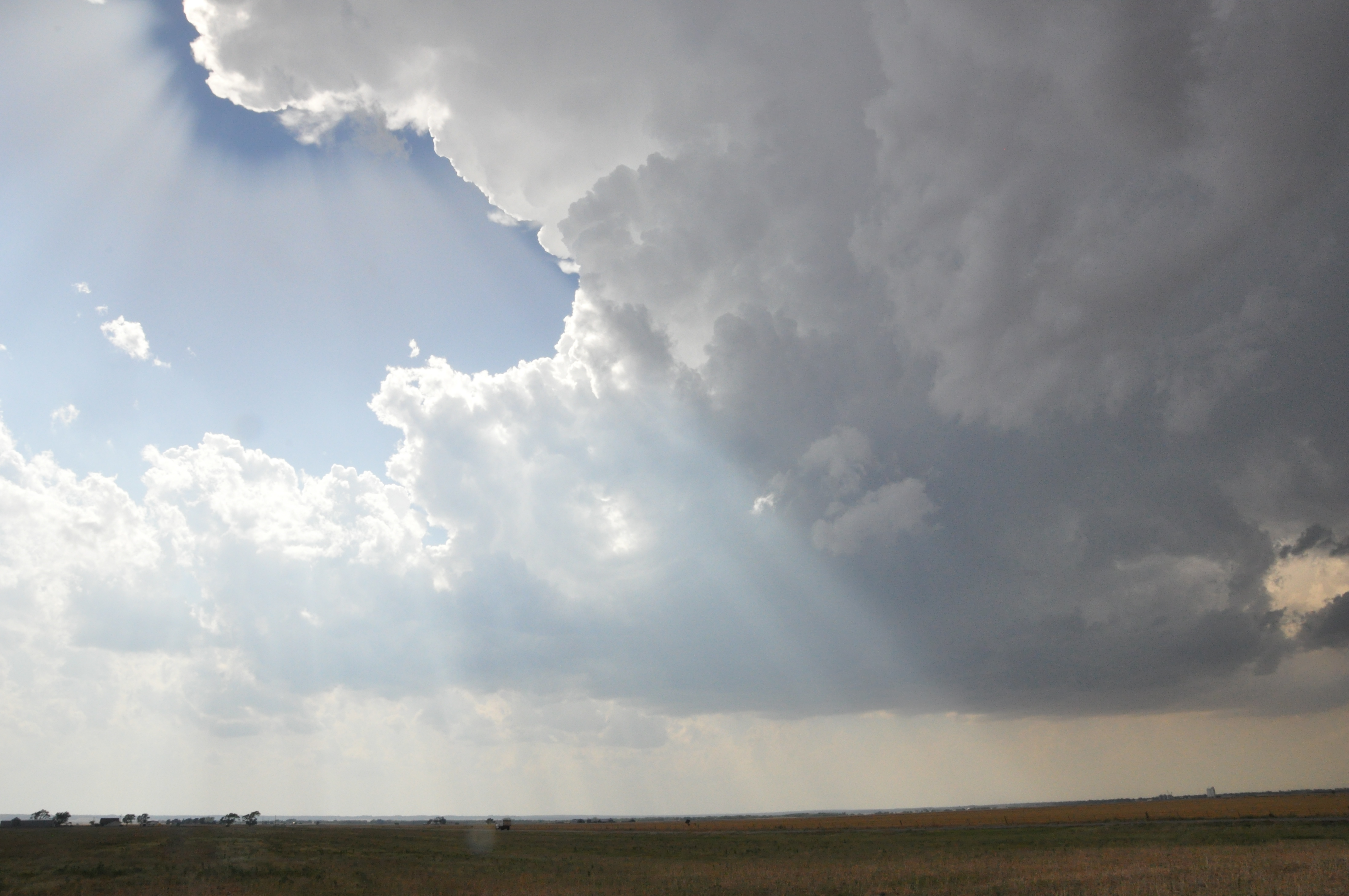 After spending the night in Wichita Falls, TX, the group had decided on an initial target of Weatherford, OK with the anticipation of driving northward to position ourselves near the triple point. The triple point is defined as the point … Continue reading →
 : Cliff Mass Weather Blog This blog provides updated forecasts and comments on current weather or other topics Tuesday , May 29, 2012 Extraordinary Skill for Extended Weather Forecasts How far into the future are weather forecasts skillful By that I mean : nbsp how far into the future can we forecast specific weather features--perhaps the intensity and position of a low pressure center or the position of a front or whether they will be rain during the early morning hours . nbsp Such forecasts contrast with climate prediction , where we attempt to predict the general nature of the weather over a period . say the average temperatures for the . spring Lately we have increasingly seen forecast skill extend well past a week . and in some cases , extending to nearly two weeks . and in this blog
 The WKU Storm Chasers rose this morning in Salina, Kansas and, after a gas station breakfast, hit the road south. Our plan was to first drive southwest of Wichita Falls, Texas, where we could reassess the situation. At 13Z this … Continue reading →
 Today began in Sioux City, IA. We stopped to get gas and preform the necessary window cleaning and Rain-X applications. While at the gas station, we noticed that Reed Timmer, storm chaser with Tornado Videos. net, and his team were … Continue reading →
 : Cliff Mass Weather Blog This blog provides updated forecasts and comments on current weather or other topics Sunday , May 27, 2012 Strong Thunderstorm Hits Portland For the second day in a row , nbsp convection and thunderstorms developed over the Cascades and rolled into the western lowlands . in this case hitting southwest Washington , Portland , and the northern Willamette Valley . nbsp Mark Albright , past WA state climatologist , reported that an observer in downtown Vancouver just W of I-5 reported 0.40 inches of rain in 5-minutes from 19:29 to 19:34 PDT 26 May 2012. The highest hourly amount from the Portland Hydra network 46 sites seemed to be the 1.34 inches over one hour from 19:00 to 20:00 PDT reported at Hayden Island just west of I-5. This is extraordinarily heavy
 This morning we woke up in Junction City, Nebraska and headed north. Unlike the day before, there wasn’t really a focal point for the storms. Our target was northeastern Nebraska where the CAPE levels were forecast up in the 5000s, so instability … Continue reading →
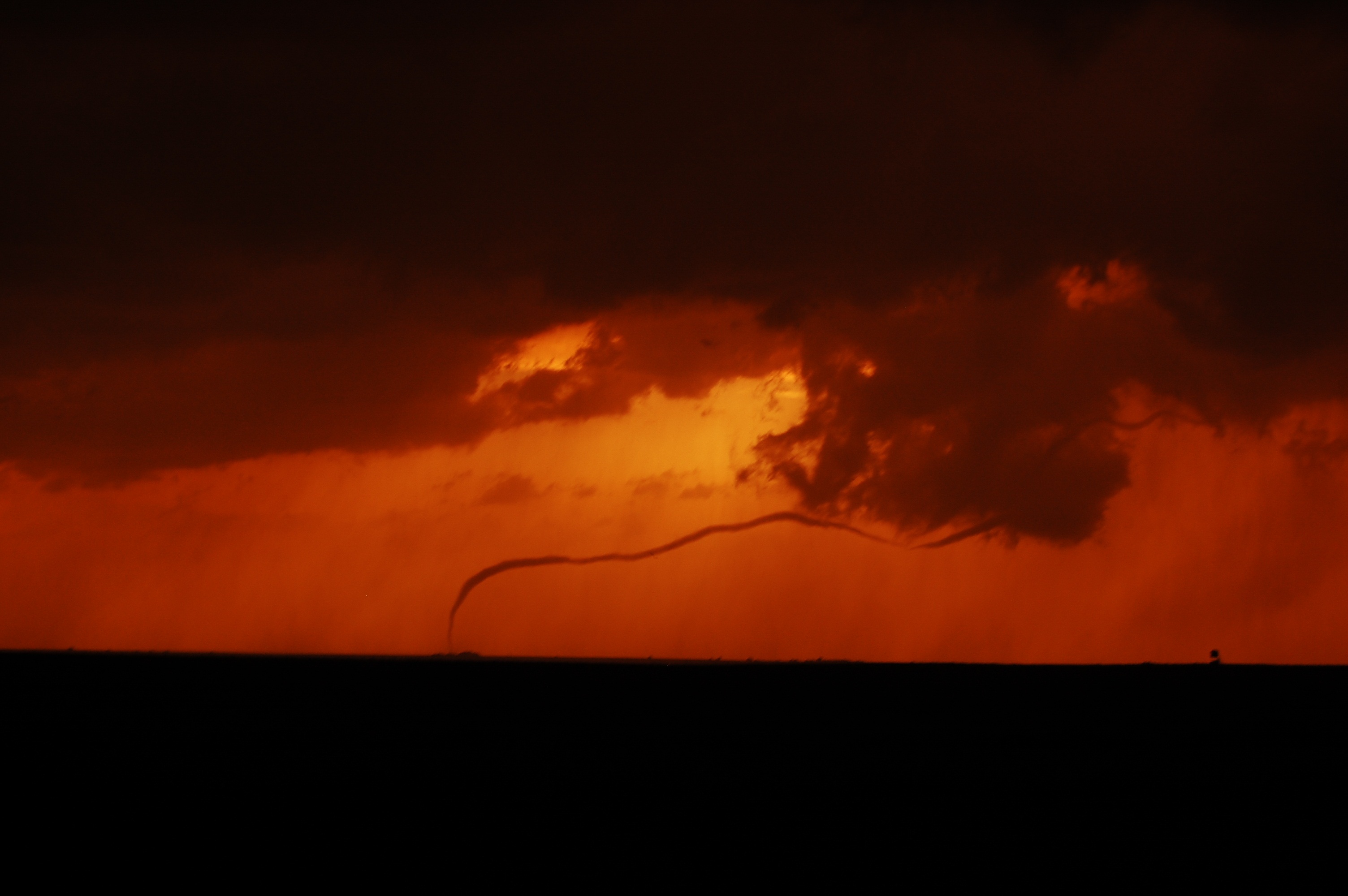 First of all, it was one of the chasers birthdays today and what a birthday it was! We started off our day in in Andover, Kansas and met up to talk about what was going to go on today. The … Continue reading →
 : , , Cliff Mass Weather Blog This blog provides updated forecasts and comments on current weather or other topics Friday , May 25, 2012 Falling Trees , Thunder , Strong Winds and a Problem Forecast This morning I didn't plan on biking home in strong winds , rumbling thunder , light rain and a blocked bike trail . but it happened . nbsp During the second half of the afternoon thunderstorms developed over and to the west of the Cascade crest and then moved over the Puget Sound lowlands . nbsp Strong outflow from the thunderstorms produced gusts of 30-40 mph , causing branches from the well-leafed trees to break off and descend upon surprised local residents . the leaves enable the winds to do more damage to the trees than would have been the case a few months ago This is what was waiting
 With the moderate risk in Minnesota and Wisconsin out of driving range from our starting point in Lincoln, Nebraska, our class decided to head south into Kansas to chase. Our target was the tail end of the cold front east … Continue reading →
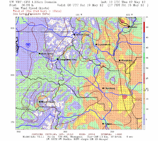 : Cliff Mass Weather Blog This blog provides updated forecasts and comments on current weather or other topics Thursday , May 24, 2012 Understanding Ellensburg's Wind As we move into the late May and June regime of low clouds a.k.a . June gloom experienced west side residents know that crossing the Cascades--east of Cle Elum and down into Ellensburg-- can bring welcome sun . nbsp A fancy resort , Suncadia , has been built for sun-starved travelers in Cle Elum , and even more sun can be found if you descend I-90 to Ellensburg and Vantage . nbsp Even Knute Berger , the old mossback , recommends Cle Elum sun in a recent Crosscut piece But there is problem . nbsp During just the days when the east-side offers the brightest contrast to the dreary west , westerly winds descend into the Kittitas
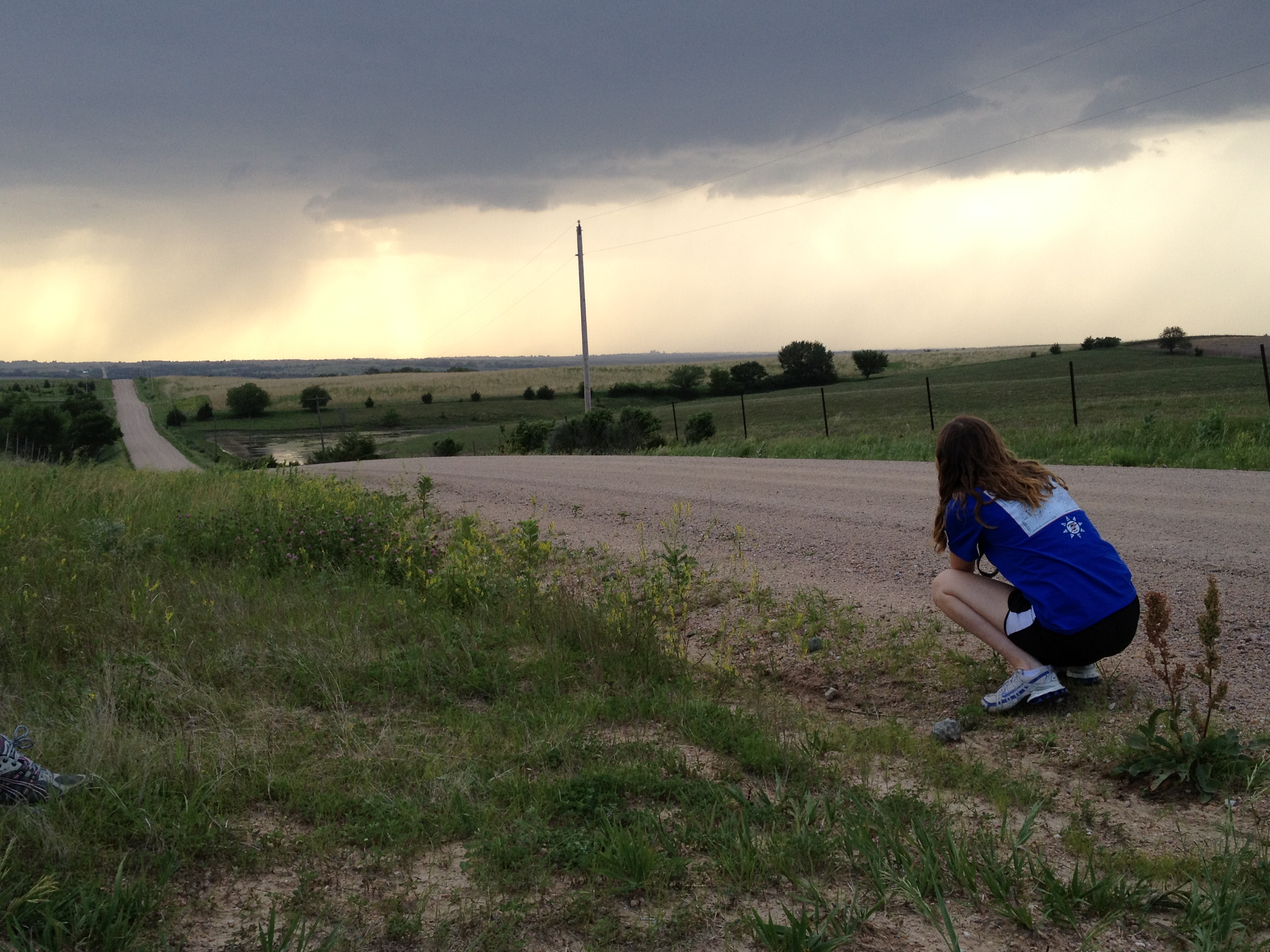 After rising early in Aberdeen, South Dakota, we analyzed the surface observations and upper air data to determine our chase target. Sufficient moisture was accompanied by 40-60 knot shear in east-central to southeast Nebraska, but highest CAPE values were limited … Continue reading →
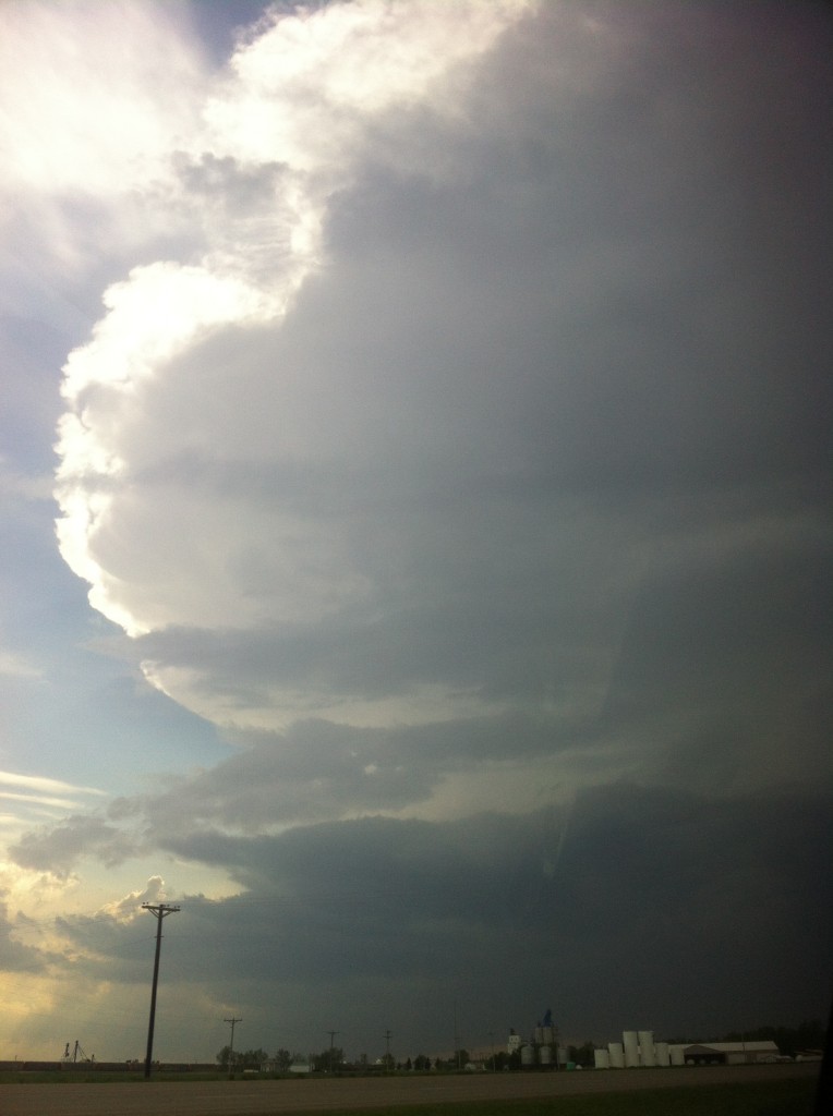 We woke up in Waterntown SD with a tough decision on our hands as we tried to discern the difficult setup that was ahead of us. Two distinct locations were discussed among the group; one being a central North Dakota … Continue reading →
 Hello readers, Now an annual event, yesterday 8 students and 2 professors embarked on a journey across the great plains to forecast and verify severe convection. This ‘storm chasing’ class is meant as a capstone experience for young meteorologists to … Continue reading →
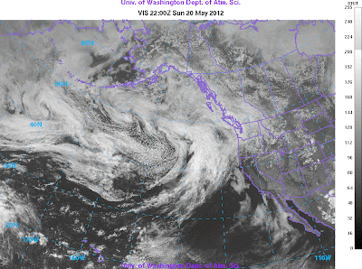 : Cliff Mass Weather Blog This blog provides updated forecasts and comments on current weather or other topics Sunday , May 20, 2012 Solar Eclipse from Space Let me show you something that is pretty . amazing It was cloudy over most of the Northwest and thus we were unable to see the annular solar eclipse from the ground . disappointing But if you can't see it from the ground , why not enjoy the view from space Can you see the eclipse from one of the National Weather Service NWS weather satellites You bet you . can Let me show you a sequence of visible satellite images from the NWS GOES-West geostationary satellite , orbiting approximately 35,000 km above the planet . Below you will see a series of these images , starting 3 PM 2200 Z--zulu time or GMT before any lunar shadow was evident .
 : Cliff Mass Weather Blog This blog provides updated forecasts and comments on current weather or other topics Saturday , May 19, 2012 Annular Eclipe Cloud Update Sunday noon update : nbsp the warm front is moving through and the rain is ending over western WA . nbsp Some breaks and thinning of the clouds can be expected during the next few . hours An annular eclipse--the sun is not completely covered by the moon Tomorrow Sunday between roughly 5:30 and 7:30 PM PDT an annual eclipse of the sun will be occurring over the U.S . West Coast . nbsp Even if it were clear , we Washington State and northern Oregon would only get a partial , off-center eclipse since the prime viewing swath will be south of us see map You can go to a wonderful eclipse calculator created by NASA found here to see
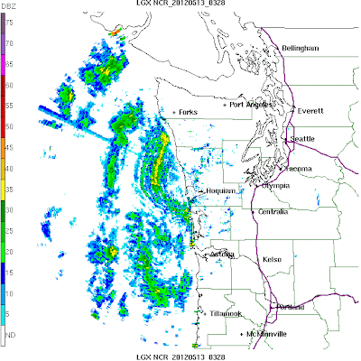 : Cliff Mass Weather Blog This blog provides updated forecasts and comments on current weather or other topics Thursday , May 17, 2012 Mysterious Ocean Precipitation Under Clear Skies For a number of days , starting on Friday , the new Langley Hill coastal radar has been showing lots of precipitation offshore , some if it heavy . nbsp Yet the skies have been clear or nearly so . nbsp Then on Wednesday the rain disappeared . nbsp What is going on And let me warn you now . these mystery showers are going to come back First , let me show you what I am talking about . here are two radar images for 8:38 PM on Friday and 6:49 PM on Tuesday . nbsp Lots of apparent rain offshore , but very little over land . very strange And lets compare these radar images to the visible satellite imagery at
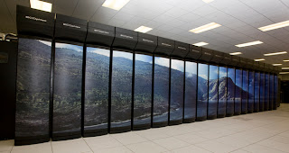 : . : Cliff Mass Weather Blog This blog provides updated forecasts and comments on current weather or other topics Tuesday , May 15, 2012 U.S . Climate Versus Weather Computers : Climate Wins W hy is the U.S . government provide hugely more computer resources for climate prediction than weather prediction And why is far more emphasis given to climate prediction research than weather prediction research and development In some past blogs I talked about the unfortunate lack of computer resources available to the National Weather Service NWS resulting in the U.S . trailing behind many international numerical weather prediction centers . nbsp This lack of computer resources undermines the ability of the NWS to run high-resolution weather models , to move effectively into probabilistic weather
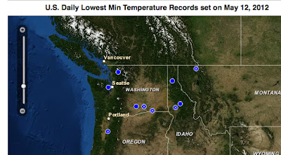 : Cliff Mass Weather Blog This blog provides updated forecasts and comments on current weather or other topics Sunday , May 13, 2012 Cold Records with Warm Temperatures On Saturday it became toasty here in Northwest , with many locations gets into the 70s and lower 80s . nbsp Yet a number of locations exprienced daily minimum temperature records in the morning--here is the proof from the National Climatic Data Center records website . nbsp The blue dot indicate a tie for the record and stations with an x set a . record To see what was going on , take a look at the vertical sounding at Spokane , WA for 5 AM on Saturday morning . nbsp With high pressure we had clear skies good infrared cooling and light winds less turbulent mixing of warm air from above Thus , air near the surface cools
 : Cliff Mass Weather Blog This blog provides updated forecasts and comments on current weather or other topics Thursday , May 10, 2012 Summer in May It is a climatological oddity of Northwest meteorology that we often get a period of very warm , dry weather sometime in the second or third week of May , followed by a retreat into the dismal June Gloom Well folks , we are about to have the heat wave--one that will bring near 80F temps to Seattle , 85F to Portland , and near 90F in Medford . nbsp The latest National Weather Service forecast for Seattle says it : all The interesting thing is that for the last few days we have had fairly cold air over us , and with relatively clear skies and good radiational cooling to space , temperatures have fallen well below freezing in the cooler spots .
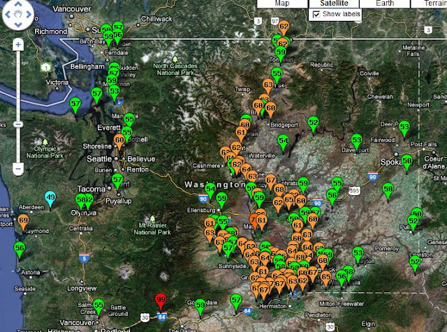 : Cliff Mass Weather Blog This blog provides updated forecasts and comments on current weather or other topics Sunday , May 6, 2012 Soil Temperatures and Gardening The question that many amateur gardeners like myself often ask : is Why are my seeds not germinating and rotting in the soil When will the soil be warm enough to sow my seeds or transplant my plants Well , I don't pretend to be an expert in this , but I suspect it has something to do so with the temperature of the soil . You can purchase or adapt a thermometer for taking soil temperature measurements Lets talk about soil temperature and how this compare to air temperature , a subject that is interesting beyond . gardening The first thing to keep in mind is that the temperatures you hear about on TV or read about in the newspaper