• Why was my flight so bumpy?

    Updated: 2010-02-28 17:24:00
    : skip to main skip to sidebar Cliff Mass Weather Blog This blog provides my latest forecast or comments on current weather Northwest Weather Workshop : March 5-6, 2010 in Seattle . A gathering for laymen and professionals Click Here for Details Sunday , February 28, 2010 Why was my flight so bumpy Aircraft wake turbulence Last night I was flying back to Seattle from the Bay Area and it got fairly bumpy at times , with the pilot periodically putting on the seat belt . sign What were the origins of that turbulence The cause last night was vertical wind shear a large change in wind speed direction with height . We were not flying in clouds or storms , and the turbulence was not connected with any terrain . feature Take a look at the vertical sounding at Medford Oregon , at about the half-way mark of my bumpy trip see graphic The pennants give you the winds-both the direction and speed big solid lines are ten knots , triangles are 50 kts The height in pressure millibars and meters are shown on the left . The plane was flying around 36000 ft , 11 ooo meters , for most the time . This is around 250 mb Between 250 and 300 mb there was strong flow from the north more than 100 knots with

  • Saturday Afternoon Weather Update – 3:45 PM

    Updated: 2010-02-27 21:56:03
    A good Saturday to you! A very nice weekend is in store, with highs in the middle to upper 50s today and sunny skies. We will likely reach the upper 50s tomorrow, with more sunny skies. Weather conditions go downhill late Monday afternoon and early on Tuesday. Due to the increasing clouds on Monday, temperatures [...]

  • Storm Facts

    Updated: 2010-02-27 17:18:42
    I came across this on the Accuweather site and thought it was pretty interesting. It has some facts behind the monster snow storm that has been pounding the New England coast over the last few days. Click here to read the story. Have a great Weekend!

  • Severe Weather Awareness Week – NOAA Weather Radio

    Updated: 2010-02-26 22:21:57
    Alabama’s severe weather awareness week concludes today with the importance of NOAA Weather Radios. NOAA weather radios can be used at any time of the day, but are especially helpful during times of inclement weather. NOAA weathe radio, which is the voice of the National Weather Service, provides continuously updated weather information 24 hours a [...]

  • Forecast Discussion Update 2/26 – 4:20 PM

    Updated: 2010-02-26 22:20:58
    Good afternoon! The final weekend of February is here and our forecast doesn’t look too bad. If you recall last year we ended the month with a big snow event. The only issue with the forecast this weekend will be lingering cold temperatures. A strong upper level disturbance is producing rain this afternoon across Louisiana [...]

  • Flood Safety

    Updated: 2010-02-25 22:23:03
    As severe weather awareness week rolls along, our focus today is on flooding and flash flooding. Flooding, and more importantly flash flooding, is the number one cause of weather related deaths in the United States. Too much rain in too little time can result in heavy rainfall accumulations. This setup can result in dangerous flash [...]

  • Forecast Discussion 2/25 3:40 PM

    Updated: 2010-02-25 21:48:54
    This is Severe Weather Awareness Week and today’s topic is flooding. On the afternoon of June 11th, 2008 a thunderstorm developed over Tuscaloosa producing nearly two inches of rain in a very short amount of time. The heavy rain triggered a flash flood event that forced the closing of many roads within the city. When [...]

  • Solar Activity Causing Satellite Distortions

    Updated: 2010-02-25 19:45:07
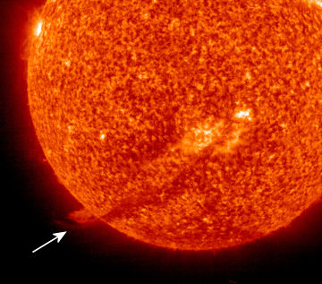
    If you’ve been trying to access satellite imagery over the past couple of hours you may have noticed some problems. Some interesting activity is happening on the sun. What’s known as a a Coronal Mass Ejection occurred a few days ago and the material is just now reaching earth. From what I have observed [...]

  • Forecast Discussion 2/24 5:04 PM

    Updated: 2010-02-24 23:04:34
    The sunshine made a welcomed return today however, another blast of cold air is settling in. A chilly north breeze will continue tonight, with lows in the middle 20s. We will drop below the freezing point for several hours tonight. Tomorrow is going to be a bright day, with temperatures rising above the freezing point [...]

  • Thunderstorm features through channel differencing in the GOES-R Proving Ground

    Updated: 2010-02-24 19:19:49
    GOES-R ABI will have several channels in the window region from which channel difference products can be produced. Four channels, 8.5, 10.35, 11.2, and 12.3 µm can be differenced to produce a total of six difference images. In this example, differences were produced from a numerical simulation of the 27 June 2007 thunderstorm event over [...]

  • Severe Weather Awareness Week: Lightning Safety

    Updated: 2010-02-23 23:47:38
      We continue today with Severe Weather Awareness Week and today’s topic is lightning safety. The summer months are the most dangerous when lightning is considered and it is known as the underrated killer. Lightning injuries and deaths can be kept to a minimum if the proper steps are taken. Here are a few tips to stay [...]

  • Tuesday Afternoon Forecast Discussion – 4:12 PM

    Updated: 2010-02-23 22:12:45
    Southern states are once again dealing with winter weather this afternoon. Several counties in east Central Texas are currently under winter storm warnings. Winter weather advisories are in place for many counties in central sections of Louisiana. A disturbance to our west will shift south of our area tonight and this may bring a shower [...]

  • Severe Weather Awareness Week:Severe Thunderstorms

    Updated: 2010-02-22 22:27:11
       Today, the first day of Severe Weather Awareness Week, the focus is Severe Thunderstorms. The definition of a severe thunderstorm is a thunderstorm that produces hail one inch in diameter and larger and/or strong wind gusts of 58 miles an hour or greater. Severe thunderstorms can produce lightning, heavy rain, and possibly tornadoes. Because of [...]

  • Inversion and A Significant Change

    Updated: 2010-02-22 02:51:00
    : skip to main skip to sidebar Cliff Mass Weather Blog This blog provides my latest forecast or comments on current weather Northwest Weather Workshop : March 5-6, 2010 in Seattle . A gathering for laymen and professionals Click Here for Details Sunday , February 21, 2010 Inversion and A Significant Change We clear skies and light winds we had perfect nighttime weather for the development of an inversion last night remember , inversions occur when temperature increases with height Take a look at the Sand Point observations ending 10 PM last . evening Temps in degrees C and height in meters . The yellow line was for 4 PM . no inversion then . But you see how quickly the inversion forms after that . evident by 6 PM , and strengthens after that . It doesn't have to be dark for the inversion to start forming , you just need more outgoing infrared radiation than incoming solar radiation to do the trick . Look how shallow the inversion is Roughly 200 meters , 600 ft . By 10 PM is was 6 C around 11 F warmer 600 ft . up Today , many locations got into the upper 50s to near 60F . And something else happened . the winds picked up a bit . Below are the observations taken at the UW for the

  • A Break from the Winter Pattern

    Updated: 2010-02-20 17:29:17
    It came, it saw, it conquered. The snowiest pattern in recent years seems to have taken a break in regards to atmospheric circumstances. High pressure has dominated the region the past few days, and will continue to do so through tonight. Beautiful conditions are in store for your Saturday, with light southerly winds advecting warm [...]

  • Big Diurnal Range in Temperature

    Updated: 2010-02-20 04:48:00
    : skip to main skip to sidebar Cliff Mass Weather Blog This blog provides my latest forecast or comments on current weather Northwest Weather Workshop : March 5-6, 2010 in Seattle . A gathering for laymen and professionals Click Here for Details Friday , February 19, 2010 Big Diurnal Range in Temperature During the last two days we have had something we haven't seen in a while . No , I am not talking about highs near 60F . although that is true . What we have had is a very large diurnal daily range of temperature . Look at the plot above at Sea Tac , today the high was 59 with a low of 39F , a 20F temperature range . far greater than we have had since December . Many locations got colder than that and frost graced many a car this . am Why so large a range Most important have been clear skies and our strengthening sun . You feel the warmth Remember the sun right now is as strong as in mid October , with much longer days than two months ago . And the clear skies associated with high pressure aloft allow maximum heating during the day and maximum cooling at night as the earth radiates infrared energy to . space But why no clouds and fog . which often occur in midwinter The secret is

  • Proving Ground: Future GOES-R - Convective Initiation

    Updated: 2010-02-19 21:32:29
    Louie Grasso and Dan Lindsey  GOES-R ABI will have several channels in the window region from which channel difference products can be produced. Four channels, 8.5, 10.35, 11.2, and 12.3 µm can be differenced to produce a total of six difference images. Shown in Fig. 1 is a loop, every five minutes, of one such difference: [...]

  • SHyMet for Forecasters Development Plan

    Updated: 2010-02-19 19:28:37
      New Developmet Plan (LMS) available! This is the forecaster track of the Satellite Hydrology and Meteorology (SHyMet) Course (similar in structure, but exanding on or covering different subjects than the intern version of SHyMet) will cover satellite imagery interpretation, including feature identification, water vapor channels and what to expect on future satellites. There is a session on remote [...]

  • Sunny Skies are Good For Olympic Snow

    Updated: 2010-02-18 04:53:00
    : skip to main skip to sidebar Cliff Mass Weather Blog This blog provides my latest forecast or comments on current weather Northwest Weather Workshop : March 5-6, 2010 in Seattle . A gathering for laymen and professionals Click Here for Details Wednesday , February 17, 2010 Sunny Skies are Good For Olympic Snow The forecasts for the next four or five days at the Olympic venues is for lots of blue skies and sun . No snow . . None Believe it or not , this is very good for maintaining snow at Whistler and Cypress Mountains The worst of the snow melt is over . The games will be ok So why is sun and lack of clouds and rain a good thing It turns out that the very worst enemy of snow is what they had a few days : ago Strong winds , low clouds and fog , heavy rain , warm air . It sounds like the plagues of Pharaoh And you know what was probably worst of all The . fog Warm air is obviously bad . it causes snow to melt . Strong winds and warm air are even worse , since the wind continuously brings more warm air to melt the surface . But believe or not , warm air is not an efficient melter of snow . It can do the job , but it takes a lot of time . In the business we call the effects of warm

  • Ridgodzilla

    Updated: 2010-02-16 04:19:00
    : skip to main skip to sidebar Cliff Mass Weather Blog This blog provides my latest forecast or comments on current weather Northwest Weather Workshop : March 5-6, 2010 in Seattle . A gathering for laymen and professionals Click Here for Details Monday , February 15, 2010 Ridgodzilla What is very big , very persistent , brings lots of heat on one side and chills on another A huge ridge and blocking pattern . or in meteorological parlance-- RIDGODZILLA And its coming to a winter Olympics in your neighborhood Take a look at at series of upper level 500 mb pressure level charts starting Wednesday at 10 AM . You will notice substantial ridging higher values of this chart indicate high elevations for this pressure level Winds are parallel to the lines . Ridging is associated with sinking air and lack of . precipitation On Friday . the ridge is stronger . now a very strong closed high . And flow and a low are now cutting undernearth into . California On Sunday . a strong high is over the NE Pacific and a low off of California . RIDGODZILLA In fact , this configuration also has another name . a REX BLOCK . and is very stable . Note : this is not named after a king , but some guy named Rex

  • Snow in all lower 48 states

    Updated: 2010-02-14 03:35:44
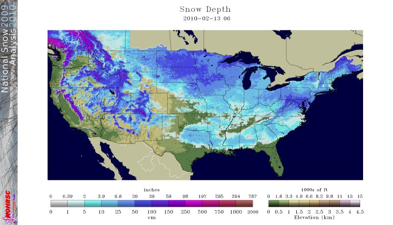
    This map of snow cover from this morning shows snow cover in all lower 48 states. This is a very rare event that has not happened in recent memory. Scientists at the Rutgers Global Snow Lab are investigating when the last time this may have happened.

  • Olympics Weather Forecast: Heavy Rain and Fog

    Updated: 2010-02-13 16:53:00
    : : skip to main skip to sidebar Cliff Mass Weather Blog This blog provides my latest forecast or comments on current weather Northwest Weather Workshop : March 5-6, 2010 in Seattle . A gathering for laymen and professionals Click Here for Details Saturday , February 13, 2010 Olympics Weather Forecast : Heavy Rain and Fog Current condition at the top of Whistler : FOG I hate to say it , but for the next day the weather for the Olympics venues will be better for surfboarding than snowboarding . Heavy rain . Thick fog . Not luge , but deluge Bringing snow to Cypress . Mt Lets face it . Our Canadian friends were mighty unlucky . a moderate El Nino at just the wrong time . And El Ninos are bad for snow . Since southern British Columbia weather is going to be a big topic for the next few days , so lets see what is going to . happen First , as any good forecaster would , lets begin by looking at the latest satellite picture . A deep low center is offshore see the spiraling clouds with a juicy looking front in the offshore waters ready to move inland . Not . good As shown in the figure below , which presents the winds and temperatures at 1 PM today at around 5000 ft , a strong current of

  • The Northwest Weather Workshop

    Updated: 2010-02-12 15:40:00
    : skip to main skip to sidebar Cliff Mass Weather Blog This blog provides my latest forecast or comments on current weather Northwest Weather Workshop : March 5-6, 2010 in Seattle . A gathering for laymen and professionals Click Here for Details Friday , February 12, 2010 The Northwest Weather Workshop On March 5th and 6th there is the Northwest Weather Workshop the annual gathering for local folks interested in Northwest weather . There is always a wide range of interesting weather talks and roughly 70 are quite accessible to laymen . Everyone from local TV weather and university types , to NWS forecasters , private sector meteorologists , and weather enthusiasts . The meeting takes place in north Seattle at the NOAA Sand Point . facility The meeting is open to everyone , but you should register if you are going . There is also a Friday night banquet , with the speaker this year talking about weather and wine growing . Generally , the meeting starts at 1 PM Friday and goes to about 4 PM on Saturday . The agenda does change a bit in time generally add a few talks In fact , if there is anyone interested in giving a talk on agriculture gardening and weather , send me an . email For

  • Why dense morning fog is a good sign!

    Updated: 2010-02-10 00:55:00
    : skip to main skip to sidebar Cliff Mass Weather Blog This blog provides my latest forecast or comments on current weather Northwest Weather Workshop : March 5-6, 2010 in Seattle . A gathering for laymen and professionals Click Here for Details Tuesday , February 9, 2010 Why dense morning fog is a good sign You wake up and look outside only to find amazingly dense fog . Like the example above . You can barely see across the street , if that . Time to get depressed about another cloudy day Pull the covers over your head and think of Maui No way Super dense fog is ironically a very good sign . one suggesting a sunny day ahead . Get out your sunglasses and your favorite recreation gear . you will probably be able to use . both How can this be true Super dense fog , like what we had two days ago , requires intense cooling near the surface . Cooling that brings the low-level air to saturation to produce a large number of fog . droplets And the most effective means of delivering such intense cooling Intense infrared radiational cooling to space from the surface . To get such cooling you need a lack of clouds and relatively dry air aloft . Why Clouds greatly lessen surface radiational

  • Humility and Forecast Busts

    Updated: 2010-02-09 04:39:00
    : skip to main skip to sidebar Cliff Mass Weather Blog This blog provides my latest forecast or comments on current weather Northwest Weather Workshop : March 5-6, 2010 in Seattle . A gathering for laymen and professionals Click Here for Details Monday , February 8, 2010 Humility and Forecast Busts Weather Prediction is a Stern Master Weather prediction is a business that promotes humility , and nothing brings one down to earth like a forecast failure--known as a forecast bust in the business . Major forecast failures are less frequent than even a decade ago . mainly due to a huge increase in satellite data and better computer models . but they still occur with discomforting frequency The most failure-prone forecasts are the most long-ranged ones . such as seasonal predictions done months in advance . Want a primo failure In the fall of 2008, we were in a neutral ENSO El Nino Southern Oscillation year and the long-range prediction was for a stormy , but normal winter . In December , there was an abrupt , unexpected turn to La Nina , with a change to cold and snow in the NW that took down our erstwhile mayor . Complete failure . embarrassing for both forecasters AND the mayor In

Current Feed Items | Previous Months Items

Jan 2010 | Dec 2009 | Nov 2009 | Oct 2009 | Sep 2009